HYDROLOGIC DATA
COMPILATION FOR THE RIO CHAMA
BY ANGELA GREGORY
|
|
|
|
|
|
|
OBJECTIVE: To determine
the hydrologic and physical characteristics of the Rio Chama Watershed in
southern Colorado and northern New Mexico that would impact suspended sediment
concentrations and bed load material in the Rio Chama.
|
|
|
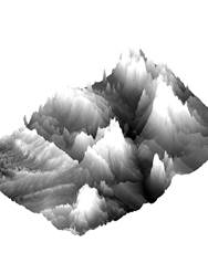
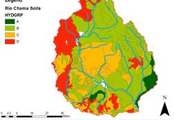
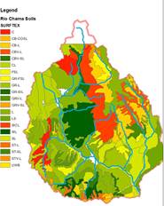
RESULTS: The maps produced showed that the highest
peaks were located along the eastern edges of the watershed. Hydrologic Soil Groups varied throughout
the watershed with poorly drained soils occurring primarily on the west
side and moderate draining soils on the east side. NRCS Soil Classification shows that
gravelly silts, and clays are predominant throughout the watershed and do
not provide enough information to explain why the west side of the watershed
is poorly draining. Slope analysis
was performed and showed high slopes on the western slopes of the
watershed.
|
|
|
|
|
|
|
|
|
|
|
|
|
METHODS: Data was
collected from the USGS Streamless Data Center, USGS
NM Water Science Center, Resource Geographical Information System, and
SSURGO. ArcMap,
ArcScene, and Microsoft Excel were used to
compile and derive data essential to the project.
ANALYSIS: Data elevation
models (DEM), HUC, streams, USGS gage locations, dam locations, vegetative
cover, hydrologic soil group, NRCS soil classifications were used to
describe the hydrologic characteristics and attributes that make up the Rio
Chama watershed. Data were projected
into NAD 1983.
|
|
|
CONCLUSION: A
large amount of knowledge was gained simply from making maps that specify
the vegetation types, hydrologic soil groups, topography, and NRCS soil
classifications. Specifically, it
was learned that the eastern side has high erodibility
potential and could be a source of sediment for to the Rio Chama. Similarly, eastern portion of the
watershed has some clay content along with high slopes and similarly could
also act as a source of fine sediment.
At this point, sediment sources are only speculative and it would be
interesting to confirm the potential sources of sediment to the Rio Chama.
|
|
|