CE 547: Assignment 5
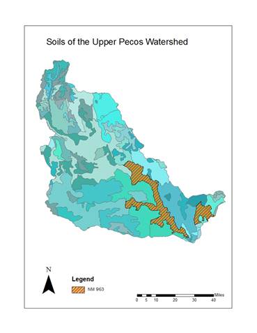
The purpose of this homework was to manipulate STATSGO data within
the Upper Pecos Watershed.
The following steps were taken:
1.
Connect to FTP and download instructor provided
data.
2.
Add NM STATSGO data.
3.
Address tilt in depiction of NM state by
clicking right-clicking Properties>Coordinate System>Modify. Change
Central Meridian to -106.
4.
Change symbology to
reflect diversity of data.
5.
Isolate upper Pecos watershed by using the clip
tool.
6.
Import NM state symbology
to clipped upper Pecos watershed.
7.
Add comp, layer, and mapunit
tables.
8.
Join tables tables by MUID.
Part 1:
- Describe
the NM963 soil in terms of its properties in the Mapunit
and Component Tables.
NM963 is an undeveloped soil type
consisting of D, and C horizons.
- How
many components does it have?
5.
- What
are their names?
Regnier, Latom,
Rock Outcrop, Los Tanos, and Gallen.
- What
percentage of the map unit does each component comprise?
Regnier
27%, Latom 27%, Rock Outcrop 18%, Los Tanos 12%, Gallen 2%.
- What
is the predominant surface slope where this soil unit is found?
0-3% slope with some
areas of greater slope.
- What
is the dominant soil texture?
Fine Sandy Loam (FSL).
- What
percentage of the soil is in hydrologic soil groups A, B, C, D?
A: 0%; B 2%; C 12%; D 86%.
- Do
these soil properties make sense considering where this soil is located?
Yes. The fine texture
of the soils are likely to be found downstream, in a lower gradient
context.
Part 2:
- For mapunit NM963, how many layers does each component
have?
- What
is the total soil depth (inches) for each layer and the average depth
(inches) for the map unit?
- What
is the total water holding capacity (inches of water) over the full soil
depth for each component?
- What
is the average water holding capacity (inches of water)for
soils in this map unit?