RESULTS
 Figure
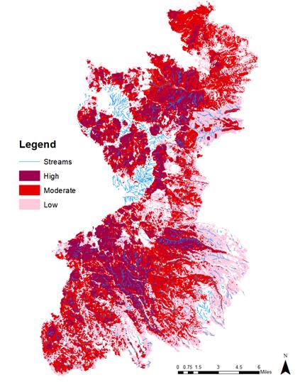
4 shows the overlay of the stream layer with the three individual layers for
each category. Total stream length added up to approximately 5 kilometers
within the affected area. The streams are divided almost evenly with each
category which means about one-third of the total stream length lies in each
category. The streams impacted by high severity fire totaled 1.87 km. Low and
moderate severity areas encompassed 1.62 km and 1.54 km, respectively. The
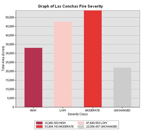
total stream length per class does not line up with the total acreage of each
class, shown in the graph in Figure 5. This is true also of the unchanged area
and the stream network within that class. Determining the
Figure
4 shows the overlay of the stream layer with the three individual layers for
each category. Total stream length added up to approximately 5 kilometers
within the affected area. The streams are divided almost evenly with each
category which means about one-third of the total stream length lies in each
category. The streams impacted by high severity fire totaled 1.87 km. Low and
moderate severity areas encompassed 1.62 km and 1.54 km, respectively. The
total stream length per class does not line up with the total acreage of each
class, shown in the graph in Figure 5. This is true also of the unchanged area
and the stream network within that class. Determining the  length
of stream impacted by different severity classes helps to inform further
research of the impacts of the Las Conchas fire on watershed health. It also
provides a brief overview of the immediate impacts such as erosion and sediment
load to
length
of stream impacted by different severity classes helps to inform further
research of the impacts of the Las Conchas fire on watershed health. It also
provides a brief overview of the immediate impacts such as erosion and sediment
load to  these
impacted streams, based off of the ranges of the loss of organic matter in the
soil.
these
impacted streams, based off of the ranges of the loss of organic matter in the
soil.