High Sloped Mountainous Area Various Saturated Groundwater Finite Element Method Simulation in
Upper Sheep Creek, Reynold Experimental Watershed,
Groundwater flow modeling has been studied as one of the main subject
of hydrogeology, and many groundwater flow simulation computer codes have been
developed since then. Although many
studies have examined groundwater flow, the hydrologic processes are still not
well understood to simulate highly sloped multiple layers. The Upper Sheep Creek Watershed, located in
southwestern
FLAMINCO successfully simulated horizontal rectangular soil column with various boundary conditions. Flux boundary conditions made the water table increase or decrease, and seepage faces played a role of discharge of the column. On the contrary, flux boundary conditions on the impermeable layer did not change the water table of the lower part of the layer. For the leaky aquifer simulation, these were needed to apply not only leaky layer soil properties, but also proper head boundary conditions. In other words, the semi-confined aquifer part should have been assumed as an independent model, and applied modified head boundary conditions as an independent model. For sloped model simulation, FLAMINCO code had several finite element construction limitations. The finite elements must be arranged normal to the plane, and shaped square, rectangular, or triangular not a diamond or a parallelogram. Rectangular and triangular shape elements can not be meshed together in one simulation model.
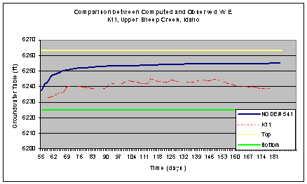

Upper Sheep Creek Watershed FLAMINCO Model Simulation
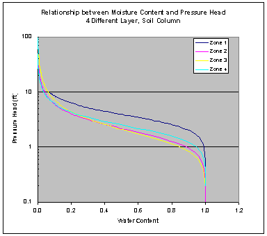
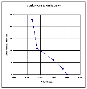
Leaky Aquifer Water Table Simulation Moisture Characteristic Curve
Evaporation Measuring by Tensiometer and VS2D Numerical Simulation in Rio Grande Bosque Area
Soil water evaporation rate estimation is the important factor for unsaturated groundwater research. The magnitude of evaporation rate may be significant in terms of the bosque water balance, and should be related with precipitation and surface water level, and external meteorological conditions of the study area. The purpose of this project is to estimate the evaporation rate around the Middle Rio Grande bosque with filed measurements, and to compare with numerically simulated results. There are three main objectives in this project. Estimate steady state evaporation rate with field measurements. Numerical simulate evaporation rate by VS2D computer model. Compare between estimation and simulation results.
The
VS2D simulated evaporation rates are different with measured evaporation
rate. As contrary the evaporation rate
was simulated the maximum 3.9 mm/day for 8 m2 surface simulated
area, the measured value varied from 0.1 mm/day to 2410 mm/day for the
elevation. The saturated hydraulic
conductivity is the most important factor for estimating evaporation rate with
filed measurements by assuming steady state conditions and the Buckinham-Darcy
law. The Rio Grande bosque area soil
type is the silty sand as defined, but the saturated hydraulic conductivity of
the silt 6 cm/day is different 210 cm/day of the fine sand, and it makes much
different evaporation rate between them.
For future study, more field measuring is needed include the soil
properties classifying and tensiometer measuring. It is recommended to measure the suction head for all simulation
area, not only one place near the river.
It is required also the VS2D model applicability for the evaporation
rate simulation. Even the VS2D model
can simulate the evaporation rate the result accuracy and limitation could be
considerable.
Matric Potential
Head Measuring with Tensiometer

VS2D Model
Application
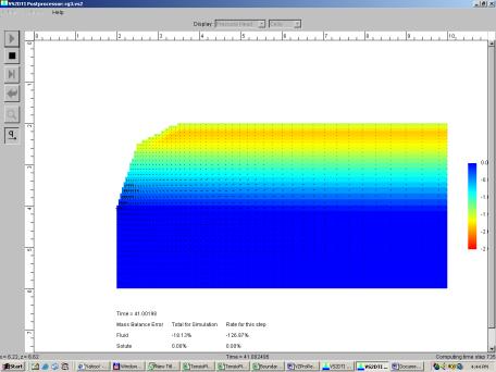
VS2D Model Simulation Results - Infiltration
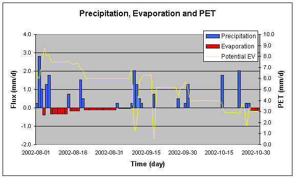
Simulated
Evaporation with Precipitation