
Ultimate Grand Canyon Backpack (Cont'd)
(Page 4 of 9)
 The next day brought us into contact with a helicopter pick-up from Hatch River boats just below Lava Falls on the Hualapai Indian Reservation side of the river. The helicopter crew asked where we were headed and when informed that Lava Falls was our destination one of them replied "it's just a bit upstream". It was actually only three miles but that section was over boulder strewn river banks not by helicopter. After leaving them, I simultaneously caught my shoulder and hiking stick between some brush and rocks and pitched head first into a flat piece of Redwall limestone. The sudden stop momentarily dazed me but the most serious consequence was profuse quantities of blood from two puncture wounds on my forehead and a broken glasses frame. Fortunately the cuts were surface lacerations and they stopped bleeding with a bandage in place. I'd only brought one pair of glasses so we taped them back together. It wasn't until later that I noticed I'd also sprained my shoulder. A bit within the Canyon becomes a substantial distance when one of many possible calamities occurs.
A succession of relatively uneventful days followed. We were able to rest for a day at Lava Falls and watch the different rafting and dory companies ride the longest Grand Canyon rapid. Frequent foot traffic around this rapid provided us with a piece of trail to walk although it only lasted for approximately a third of a river mile. Conditioned by our previous lower-Canyon hardships, we hiked the brushy river bank from Lava Falls to Tuckup at a seemingly leisurely pace. I was happy to be on what I considered home ground. More comfortable because from here to Lee's Ferry, with a single exception, I had walked the route on one side of the river or the other. The removal of all uncertainty about our planned route seemed to free us from a psychological barrier and made it only a matter of covering the remaining ground.
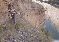
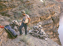 Even the Muav cliff section from river mile 162 to Matkatamiba Canyon was of less concern now. For nearly 20 miles the river's edge was bounded by sheer Redwall cliffs. Fortunately, a continuous talus ledge existed several hundred vertical feet above the river and offered the possibility of passage without using Colin Fletcher's Esplanade Route. These ledges had only been walked by one modern day hiker, Kenton Grua, and we had the good fortune of talking to him at Lava Falls when a Grand Canyon Dories trip passed. Kenton was one of their guides. He informed us that our proposed route was indeed feasible and that drinking water was available in Sinyala Canyon when we would be isolated above the river. Since Bob and I had walked the ledges from Havasu Creek to Tuckup the previous year, our last reservations about this route disappeared. Much of the route during this multi-day period of isolation from the river was on bighorn sheep traces which stretched across this little used precipitous area. After three days of 60 to 80 degree angled slope walking we reached Matkatamiba Canyon. Both upstream and downstream from Havasu Creek we encountered several sets of mysterious cairns in groups of three and four. Since no mining activity was evident we concluded that Grand Canyon's original human inhabitants had placed these markers for unknown reasons.
[first page | previous page | next page | last page].
Updated on Thursday, November 3, 2011 @ 4:30 MST
© 1995-2011 by Robert R. Marley |