Miguel
Santistevan
CE
547 – J. Coonrod
Class
Project
May
12, 2008
New Mexico’s Food Shed
Abstract
New Mexico can be known for its rich history of
agriculture: from indigenous populations, to the Spanish entry and influence,
to modern day specialty foods like chile and prolific
conventional agriculture such as the dairy industry. In times of climate change and food crises
around the globe, the question is often posed if there are sufficient land and
water resources to sustain the local population. A GIS analysis of USDA Agricultural Census
data for 1997-2002 was performed as the beginnings of a longer term study that
will be used to understand the nature of New Mexico’s ‘food shed’ and the
potential of existing (and future) agricultural infrastructure to provide for
the population of the state.
Objective
The objective of this study is to use the tools available
in GIS to analyze the character of New Mexico’s agriculture with regard to the
types of crops grown in each county, the acreage in those crops, and the
environmental conditions associated with those counties. The kinds and amounts of different crops for
each county is of interest to understand the nature of crop diversity in each
county; and the environmental conditions, including precipitation, evaporation,
and other potential environmental factors (soils, irrigation augmentation to
moisture regime, elevation, slope, etc.) will be of interest to determine
appropriate crops for particular environmental conditions. The ultimate objective of this analysis will
be to understand the nature of crop diversity in the individual counties with
regard to their environmental conditions and to be able to determine how their
agricultural production could be shifted, based on the acreages of particular
crops, to maximize diversity in a manner that is appropriate and optimal given
those environmental factors and constraints.
Methods
Base maps were obtained from RGIS (rgis.unm.edu),
including county seat locations, state, and county boundaries. Precipitation and evaporation isopleths were
also obtained from RGIS. The data for
crop production was obtained from the USDA 2002 and 1997 Agricultural Census
Data (available at www.nass.usda.gov/census/census02/volume1/nm/index2.htm).
Results
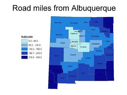
To determine the nature of New Mexico’s ‘food shed,’ road miles from Albuquerque to the various County seats was
determined using the distance tool in ArcView. The importance of this calculation is to determine
how far food would have to travel from the various counties to be able to
sustain the population of Albuquerque (Figure 1).
Figure 1.
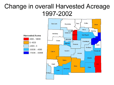
To understand the trends in agricultural production
across the State of New Mexico, data was analyzed to determine the change in
harvested acres from 1997-2002. This
information is related in Figure 2 and gives an indication of which counties
are gaining and losing acreage in agriculture.
Figure 2.
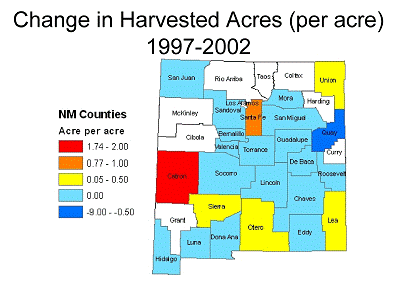
In order to standardize the trends in agricultural
production for the various counties, and analysis was performed to determine
the amount of acreage gained or lost per acre of 1997 production. This information is related in Figure 3.
Figure 3.
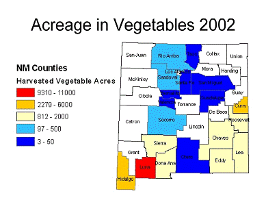
To visualize the spatial relationships of vegetable
production across the State, a map was created that relates the harvested acres
in vegetables in 2002 (Figure 4).
Figure 4.
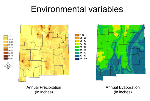
To begin the analysis of environmental data for the
counties of New Mexico, maps of precipitation and evaporation were generated
and rasterized (Figure 5).
Figure 5.
Conclusion
This project represents the beginnings of a lengthy and
ongoing analysis that is required to understand the nature of New Mexico’s food
shed with regard to crop diversity and environmental variables. From these preliminary results, it was found
that most counties in New Mexico are losing agricultural acreage except for six
counties (Catron, Santa Fe, Lea, Sierra, Otero, and Union) who are experiencing
agricultural increases to varying degrees.
Future
Work
Indices of environmental characteristics will be
determined from precipitation and evaportation coverages for each county.
The existing crop diversity for each county will then be related to
environmental indices to analyze the cropping strategies for the counties. Vegetable production data was used for this
initial analysis that will have to expand to all major commodities produced in
the counties (maize, wheat, sorghum, etc).
Precipitation data will have to be augmented with irrigation data to
account for the moisture regime potentially available to crop production in the
various counties.
Acknowledgements
Special thanks to Bruce Milne and Sustainability Studies
for the conceptual inspiration and direction in this project.