Contouring Procedure: The creation of precipitation isohyets was fundamental in this study. Consequently, ArcView’s powerful contouring tools were manipulated in various ways to obtain realistic rainfall patterns. A summary of this manipulation appears in Figures 1-3 below.
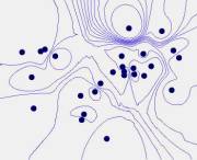
Figure 1. The Inverse Distance Weighted Method gives more
weight closer to data points. This
creates precipitation peaks that are too localized.
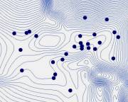
Figure 2. TheTension Spline Method eliminates extreme
peaks and gives smoother contours. However, it also creates spurious contours
in the southeast portion of the map.
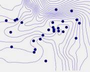
Figure -3. The Tension Spline Method creates contours
with good smoothness and localization around data points. This method was selected to create isohyets
for Albuquerque, NM.