WORKSHOPS

CONFERENCE ON SPATIAL INFORMATION THEORY XII


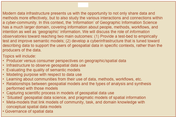
Geographic Information Observatories (GIO 2015)

How, Who, and Why of Spatial Information


Close

Modern data infrastructure presents us with the opportunity to not only share data and methods more effectively, but to also study the various interactions and connections within a cyber-community. In this context, the ‘Information’ of Geographic Information Science has a much larger domain, covering information about people, methods, workflows, and intention as well as ‘geographic’ information. We will discuss the role of information observatories toward reaching two main outcomes: (1) Provide a test-bed to empirically test and improve semantic models; (2) develop a cyberinfrastructure that is tuned toward describing data to support the users of geospatial data in specific contexts, rather than the producers of the data.  
Topics will include:
•	Producer versus consumer perspectives on geographic/spatial data
•	Infrastructure to observe geospatial data use
•	Evaluating the quality of semantic models
•	Modeling purpose with respect to data use
•	Learning about communities from their use of data, methods, workflows, etc.
•	Relationships between geospatial models and the types of analysis and synthesis performed with those models
•	Capturing scientific process in models of geospatial data use
•	‘Situated’ geospatial data science, and pragmatic models of spatial information
•	Meta-models that link models of community, task, and domain knowledge with conceptual spatial data models
Governance of spatial data
workshops.htmlshapeimage_1_link_0
NEWSNews.htmlshapeimage_3_link_0