GEOG585: Internet
Mapping: Lab 5
Question 1
1) There are a large number of WMS services available on the web. One way
to find
interesting services is to search for them using standard search engines
such as
Google. Try searching for the following phrases: “REQUEST=GetCapabilities”
and
“SERVICE=WMS”.
- What search engine did you use?
- How many ʻhitsʼ did you get?
- How useful (in terms of getting a pointer to a live WMS service)
were the ʻhitsʼ?
Answer:
- Lycos
- 3940
- There were many sites that listed other WMS links but not many
direct links in the search list.
Question 2
2) Pick two of the services that you found above, and answer the
following questions
about each.
- What is the URL for the full GetCapabilities request to the service?
- What is the Name of the service?
- What Format(s) are available for GetMap requests from the service?
- How many layers are included in the service?
- For one of the layers in the service,
1) what is the SRS of the layer?
2) what is the name of the projection that matches the SRS EPSG code?
3) what is the LatLonBoundingBox of the layer?
Answer: -
http://nsidc.org/cgi-bin/acap.pl?service=WMS&request=GetCapabilities&version=1.1.1
-
OGS:WMS
-
png, tiff, gif
-
4 layers
-
EPSG:3031, WGS 84 / Antartctic Polar Stereographic, -180,-90,180,90
- http://nsidc.org/cgi-bin/atlas_north?service=WMS&request=GetCapabilities&version=1.1.1
- OGS:WMS
- gif, jpeg, png
- 5 Layers
- EPGS:32661, WGS 84 / UPS North, -180, -90, 180, 90
Question 3
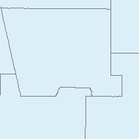
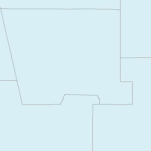
3) Open the following GetCapabilities request in your browser. Select
“View Source” from one of the browser menus to see the delivered XML
document (it will appear as an unformatted string of text by default in your
browser). Use the information in the XML capabilities document to formulate
GetMap requests for the following map images. Include the requests and
resulting images in your write-up.
Answer:
http://gstore.unm.edu/apps/rgis/datasets/97810/services/ogc/wms?VERSION=1.1.1&SERVICE=WMS&REQUEST=GetMap&BBOX=-107.2,34.7,-106,35.25&WIDTH=200&HEIGHT=200&SRS=EPSG:4326&FORMAT=image/jpeg&LAYERS=2007fe_35_county00&STYLES=
http://gstore.unm.edu/apps/rgis/datasets/97810/services/ogc/wms?VERSION=1.1.1&SERVICE=WMS&REQUEST=GetMap&BBOX=-107.2,34.7,-106,35.25&WIDTH=500&HEIGHT=500&SRS=EPSG:4326&FORMAT=image/png&LAYERS=2007fe_35_county00&STYLES=
Question 4
4) Open the following (linked) KMZ file in Google Earth, uncompress it,
and save the contained KML file on your computer. Open the KML file in
Notepad. Add a second Placemark element to the KML file that represents a
square region that is completely contained within the state boundary. Save
the KML file and open it in Google Earth. Submit the KML file (as a link in
your writeup) as part of your writeup for the lab.
Answer:
Updated KMZ file
|