GEOG585: Internet
Mapping: Lab 6
Question 1
1. Given that McKinley County NM is contained within the following BBOX:
-109.1,
34.5, -107.0, 35.4, answer the following questions:
- What is the aspect ratio of this geographic region? 2.33333
- What would be the height (in whole pixels) for a map image for this
region that is 600 pixels wide? 257
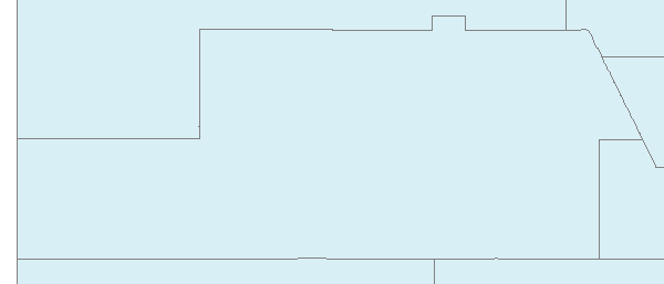
- Formulate a WMS request that reflects the values determined in 1.1
and 1.2 above for the WMS service used above in the examples. Include in
your answer both the actual WMS request and the returned map image.
http://gstore.unm.edu/apps/rgis/datasets/97810/services/ogc/wms?VERSION=1.1.1&SERVICE=WMS&REQUEST=GetMap&BBOX=-109.1,34.5,-107,35.4&LAYERS=2007fe_35_county00&FORMAT=image/png&TRANSPARENT=TRUE&STYLES=&SRS=EPSG:4326&WIDTH=600&HEIGHT=257
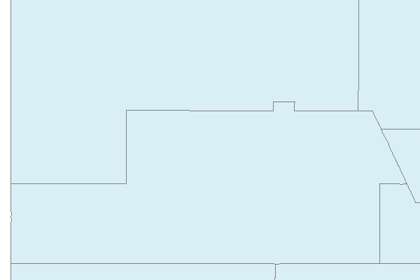
- Formulate a WMS request for a 600x400 pixel map image that
represents the full width of the defined geographic region, and is based upon the minimum Y value of 34.5 degrees North Latitude. Include in your answer both the WMS
request and the returned map image.
http://gstore.unm.edu/apps/rgis/datasets/97810/services/ogc/wms?VERSION=1.1.1&SERVICE=WMS&REQUEST=GetMap&BBOX=-109.1,34.5,-107,35.83&LAYERS=2007fe_35_county00&FORMAT=image/png&TRANSPARENT=TRUE&STYLES=&SRS=EPSG:4326&WIDTH=600&HEIGHT=400
Question 2
2) Given a WMS that is represented by the following GetCapabilities
request, formulate
individual GetMap requests for each of the following layers: bmng2km,
bmng500mA1, landsat, and doqq05
http://edacwms.unm.edu/cgi-bin/mapfiles/edacimagery?SERVICE=WMS&VERSION=1.1.1&REQUEST=GetCapabilities
http://edacwms.unm.edu/cgi-bin/mapfiles/edacimagery?SERVICE=WMS&VERSION=1.1.1&REQUEST=GetMap&LAYERS=bmng2km&BBOX=-108,33.5,-102,39.5&FORMAT=image/png&STYLES=&SRS=EPSG:4326&WIDTH=308&HEIGHT=308
http://edacwms.unm.edu/cgi-bin/mapfiles/edacimagery?SERVICE=WMS&VERSION=1.1.1&REQUEST=GetMap&LAYERS=bmng500mA1&BBOX=-108.1,33.5,-107.1,34.5&FORMAT=image/png&STYLES=&SRS=EPSG:4326&WIDTH=298&HEIGHT=298
http://edacwms.unm.edu/cgi-bin/mapfiles/edacimagery?SERVICE=WMS&VERSION=1.1.1&REQUEST=GetMap&LAYERS=landsat&BBOX=-108.1,33.5,-107.1,34.5&FORMAT=image/png&STYLES=&SRS=EPSG:4326&WIDTH=1429&HEIGHT=1429
http://edacwms.unm.edu/cgi-bin/mapfiles/edacimagery?SERVICE=WMS&VERSION=1.1.1&REQUEST=GetMap&LAYERS=doqq05&BBOX=-108.1,35,-108,35.1&FORMAT=image/png&STYLES=&SRS=EPSG:4326&WIDTH=1964&HEIGHT=1964
- Which layers return map images that display image content?
All at the proper scale
- Sometimes when WMS layers are accessed, there is a limit on the map
scales
for which the map image will be returned. If a request is submitted for
a map
scale that is outside the range specifed for a given layer, typically, a
blank
map image will be returned. From examining the information for these
layers in
the GetCapabilities XML document - which element in each layerʼs service
metadata do you think provides information about the scales for which
the
layer will return map images containing data? <ScaleHint>
- You can effectively change the scale of a map image by changing the
pixel
dimensions of the requested image. Which map images contain data for
each
of the following map image widths (remember to adjust the image height
to
match the BBOX of the request)
1) 100 pixels bmng500mA1
2) 1000 pixels Landsat, doqq05
Question 3
3) Below is a link to a KML file that includes a single GroundOverlay
element that, in
turn, contains a single Icon and href element that contains a WMS request
(including
all layers in the service in the “LAYERS” parameter) to the imagery service
you
worked with in question 2, above.
https://docs.google.com/leaf?id=0B631pWlrK6GGZTAxOGM4NTQtOTQyOS00NjU2LWJjN2MtZjc0OGFiOWZlZmQ4&hl=en
- Open the supplied KML file in Google Earth and enable it by clicking
the
checkbox next to its name in the “Temporary Places” pane on the left side of
the user interface. Zoom in over several steps to the intersection of
Interstate
25 and 40 in Albuquerque. What do you notice as you stop zooming?
Refreshes with scale dependant layer
- How does what you see relate to the scale dependencies that were
highlighted in question 2 above? Each scale range brings in a new
layer
- Open the KML file in a text editor (like Notepad). Using the
original
GroundOverlay element and its content as a template, create new KML files,
one for each layer in the original, with each of the multiple layers in the
original
file being the only one included in the Layers parameter of the WMS request
in
the href element (remember to rename the GroundOverlay element so that
they can be distinguished in the legend).
KML files: SW_KML.rar
- What happens when you add the KML file depicting bmng2km to Google
Earth? A nice raster overlay is added on top of google earths
standard image of the southwest.
- What happens when you change (by editing the KML file, saving the
change,
and re-adding the file to Google Earth) the image format in the KML WMS to
image/png? If there is a change in what you see, why do you think it
happens?. PNG looks good
Question 4
4) BONUS Question - What WMS parameter(s) are missing from the href
element in
the GroundOverlay in the KML? Why do you think it/they are missing?
SERVICE=WMS, BBOX. GE is smart enough to calculate the
extent of the region.
|