Few archaeological contributions have been as massive—or as controversial--as the excavations at Paquimé. Even the spatial extent of the site is open to question. Di Peso (1974 II:376, Fig. 56.2) argued that the core of Paquimé was arranged as an inverted U, with the opening to the south (Figure 1). The west wing of the U was the multistory complex familiar to visitors and partly excavated by Di Peso. The top of the inverted U was tested during Di Peso's project. The east wing of the U was neither excavated nor tested; it is shown on site maps but no description was provided in the report. Additional, smaller mounds are also illustrated on maps in the east half of the site, but were not described (Di Peso 1974; Di Peso et al. 1974). In this essay we explore the debate over the nature and extent of the non-excavated portion of Paquimé. To so, we distinguish the "east half" of Paquimé (an area containing an unknown amount of prehistoric remains) from the "east wing" of Paquimé (a hypothesized multistory structure within the east half of the site).
Di Peso's arguments for a multistory wing and other structures in the east half of the site are highly relevant to his notion that Paquimé was different from other sites in the region. Di Peso's projected a larger population at Paquimé—about 3,000 persons in his Paquimé phase, even more in his Diablo phase—than was typical of sites in the North American Southwest. If, however, the habitation zone in the site was not much larger than the area he excavated or tested, Paquimé was within the usual range for late prehistoric pueblos. Which version is the truth: Di Peso's "double" Paquimé, the version indicated by the obvious remains, or something in between? In this essay we examine the available evidence. Nonetheless, the issue will not be laid to rest until Di Peso's postulated "east half" of Paquimé is tested archaeologically. We hope that this essay will help stimulate the necessary field studies.
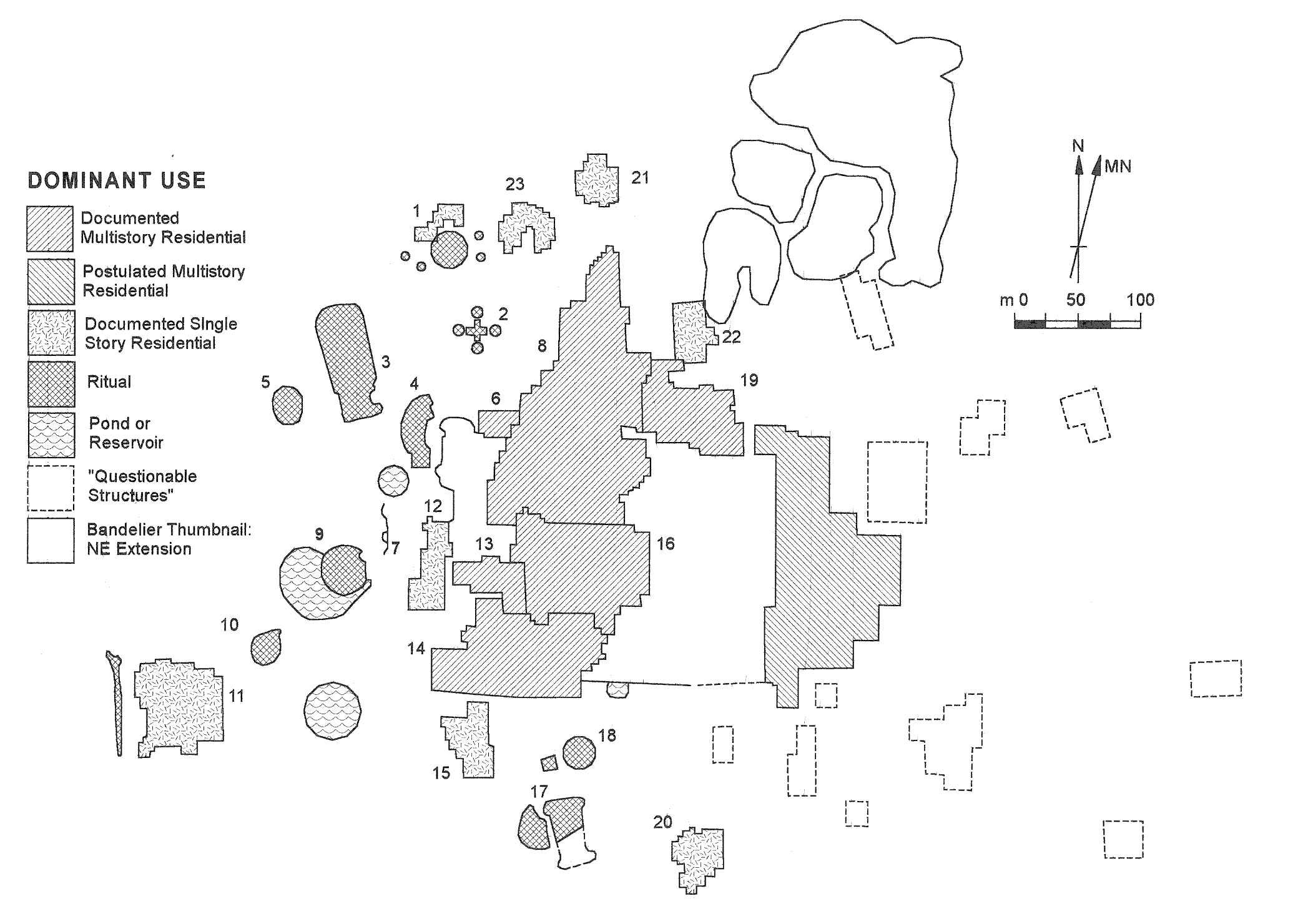
The controversy exists, in part, because Di Peso's 1974 excavation report was ambivalent about the "east half" of the site. In one case the multistory east wing was described as "postulated" (Di Peso 1974 II:376, Fig. 56-2). Figures 451-2 (Di Peso 1974 II, end papers) and 121-4 (Di Peso et al. 1974 IV:196-197) label the east half remains as "surface indications of structures" as opposed to the excavated and trenched structures of the west wing. Figure 124-4 (Di Peso et al. 1974 IV:200) labels the east half remains as "surface indication only, questionable use." Figure 125-4 (Di Peso et al. IV:201) labels part of the east wing as a high-rise structure but the remaining east half buildings as "questionable structures."
It is also instructive to compare the final excavation report to Di Peso's earlier description of the site in the Handbook of Middle American Indians (Di Peso 1966). Here, Di Peso made no mention of an east wing and treated the central plaza of the west wing as the central plaza of the entire site. As the Handbook article postdates Di Peso's fieldwork, we infer that Di Peso reached his final conclusions about the east half of the site during the later stages of analysis and report preparation.
The ambivalence in the report derives, it seems, from the ambiguity of the available evidence. We found only one description of how the east wing structures were identified, in Figure 129-4, Note 2: "The outline of the east half of the city was obtained from data gathered from ground survey and aerial photos" (Di Peso et al. 1974 IV:204). Assuming that this part of the site did exist, how did Di Peso know that the east wing was multi-storied? The answer seems to be, he did not. Because the excavated and trenched portion of the site core was multi-storied, Di Peso projected that quality onto the postulated but non-excavated, non-tested portion of the site. Footnote 6 of Figure 129-4 indicates how the size of the eastern "high rise" section was determined: "Since two of the three wings of the high-rise fell within the west half of the city, the proportion for the average size of the two was projected to the east half" (Di Peso et al. 1974:IV:204). The note for Figure 130-4 restates this approach as follows: "The average square meter high-rise was projected to the east wing; the difference between this figure and the projected proportion was added to open plaza areas." In other words, the claimed extent of upper-story construction in the east wing was based on a statistical extrapolation, not on empirical observations.
It would have helped if the excavation report included aerial photographs of the east half of the site—and one would expect such photographs to be part of the report. However, all of the excellent aerial photos in the excavation report (and in Di Peso's 1966 Handbook article) show only the west half of the site. Indeed, some photos appear to be cropped to exclude the east half of the site. We suspect that the prints were prepared before Di Peso developed his final interpretation of the east half of the site.
Among the scholars who have examined Di Peso's model of Paquimé, a common reaction is to eliminate the east half of the site. As Stephen Lekson (1999b:86) has described:
Subsequent redrawings from Di Peso's map deemphasize and even delete the central [East] plaza and the east wing, showing only a single room block facing the river valley, with ball courts, mounds and detached compounds on the reverse, away from the river (cf. Ravesloot 1988:Figure 1.2 and Bradley 1993:Figure 2). Compared to Di Pesos's original map, we've lost half the site!
Might these editorially truncated presentations be, in fact, correct? David Wilcox suggested at a professional forum that the east arm of Casas Grandes is, in fact, a natural ridge on the Rio Casas Grandes floodplain (David Wilcox, remarks at the Southwest Symposium, Tempe, Feb. 10, 1995). Wilcox proposed his hypothesis based on his surface examination of the site and on a manuscript map by Adolph Bandelier.
In the same essay Lekson takes up the cudgel of the "east wing" in his attempt to convince readers that Casas Grandes was more a Southwestern Puebloan site than a Mesoamerican site.[1] Lekson's epistle continues:
Bandelier's unpublished and published maps of Casas Grandes (Bandelier 1892:Plate 7; reprinted, along with an "unpublished" Bandelier map, in Di Peso 1974:Figure 14-4; the latter published by Burrus 1969:Plate 26) indeed do not include the east arm and eastern outbuildings shown by Di Peso on his maps of Casas Grandes (e.g., Di Peso et al. 1974:4:Figure 121-4). However, in his field journals Bandelier noted that modern Mexican settlement encroached on the ancient ruins of Casas Grandes: "[T]he dozen [Mexican] houses, east of the ruins, still partly stand on ruins, and some of them are built on ancient walls. On the whole, the [ancient] settlement has been very extensive, and expanded into the river bottom proper" ("Field-Notes of Casas Grandes" in Lange and Riley 1970:294–295). In Bandelier's phrase "east of the ruins," the term ruins almost certainly refers to the west arm (as represented on Bandelier's maps). Bandelier recognized but did not map "ruins" and "ancient walls" east of the west arm; I assume that these "ruins" and "ancient walls" were at least in part the architectural units Di Peso later called the east arm. Thus, Bandelier's map did not present the entire site as it was known to him but only the better-preserved western half. Wilcox's doubts about Di Peso's east arm are not, in fact, supported by Bandelier's notes, maps, and published conclusions.
My admittedly brief examination of the "east arm" indicates that it is, in fact, a very large adobe room block. This opinion is shared by others familiar with the site (e.g., Paul Minnis, personal communication, Feb. 10, 1996; John Carpenter, personal communications, Feb. 10, 1996), although other archaeologists share Wilcox's view (e.g., David Phillips, personal communication, Aug. 10, 1996). Di Peso, of course, expressed no doubt that the east arm was real. He described and mapped Casas Grandes as "a south oriented, multistoried apartment building having three arms or wings (east, north, and west) built around a large public plaza which was walled on its south side (the 'East' Plaza)" (Di Peso et al. 1974:4:Figure 129-4). Why did Di Peso not excavate the east arm? "Due to the fact that the eastern sector of the city was occupied by some 53 families, which the government of Mexico wisely decided not to move, the target area was confined to the west, where eleven families lived. To these, the Republic gave not only land and riparian rights, but also new homes" (Di Peso et al. 1974:4:128).
The reality of the east arm is a resolvable issue; the east arm can be confirmed or disconfirmed through excavation. However, the possibilities for excavation in the east wing are currently remote and will probably remain so in our lifetimes. Absent new excavation data, I prefer to believe Di Peso. In addition to the mutually supporting archival and published evidence, my reasons for trusting Di Peso are frankly ad hominem. Whatever the interpretive or theoretical quibbles one might have with Di Peso's work at Casas Grandes, few doubt his remarkable abilities as a field archaeologist. Di Peso knew the site better than anyone before or since his extended fieldwork [Lekson 1999b:86].
Lekson's discussion tends to equate the east half of the site with Di Peso's east wing. The existence of the former does not, however, prove the existence of the latter.
David Wilcox, the other most active voice in this debate, addresses the issue in the same volume. Wilcox's map of the site (1999:97, Fig. 7.2) shows all of Di Peso's east half structures, but he is clearly dubious:
Di Peso's excavations were concentrated on the western side of the site, where the majority of ceremonial mounds and ball courts are located. In his general map of the site ... he postulates a series of room blocks east of the main ruin whose overall layout, he implies, defined a large plaza. ... [A]s I have discussed elsewhere (Wilcox 1996), Bandelier's (1892; Burrus 1969) map of Casas Grandes does not show such a plaza. This is odd because Bandelier was a superb observer, he was there 75 years or more before Di Peso, and he was familiar with what we call Pueblo IV pueblos. This particular "plaza" may not exist ... and if it does not, certain other of Di Peso's inferences will have to be reevaluated, such as his population estimates, which depend heavily on assumptions about the size of these putative eastern room blocks. Fresh field research, a detailed mapping of this area, and perhaps excavations are needed to resolve this issue [Wilcox 1999:98].
Wilcox's 1996 paper, previously cited, has this to say about the matter:
The most detailed and intriguing of [Adolph Bandelier's watercolor maps of northwest Mexican sites] is that of Casas Grandes ... A black and white version was published by Bandelier (1892:Plate VI). What is most striking about this portrayal of the site, which is based on observations made over 100 years ago, is it does notindicate the room block inferred by Di Peso et al. (1974:Fig. 215.5 [...]) to encircle a large, Southwestern-style plaza, yet Bandelier's map includes the putative plaza area. Di Peso et al. (1974:Fig. 128-4) are clear that this eastern room block is "postulated." At the 1991 Pecos Conference that was held at Casas Grandes, I walked over the area of the presumed block but could find nothing to support the hypothesis. Bandelier's map raises further doubts. Bandelier (1892:547) also says, explicitly, that "there is nowhere, as far as I was able to detect, any square or public yard of considerable extent [at Casas Grandes]."
This issue is important for two reasons: (1) if Paquimé did have a large central plaza like other P[ueblo] IV sites in the American Southwest, it suggests organizational similarities that may not have existed; and (2) if it did not, then we must ask whether Di Peso's estimate of Paquimé's population, which is based on a measure of total floor area, included area inferred from this large but hypothetical room block. If it did, the finding that Paquimé was larger than any other Southwestern site may have to be revised downward. If it were a third less, for example, instead of 3000 people (Wilcox 1991:148), Paquimé may have had only 2000 people, as did Pecos and other large Southwestern sites [Wilcox 1996:11-12; emphases in original].
As Lekson and Wilcox use Bandelier's evidence to reach such different conclusions, it is useful to examine that evidence directly. Fortunately, that evidence is published. Bandelier visited Paquimé in 1884, took field notes and measurements, and drew a series of maps. Eight years later he published his report on the site, including one small and one large map of the site (Bandelier 1892). About this time, Bandelier also prepared an illustrated history of the Southwest that is archived at the Vatican. One of the illustrations, a watercolor version of Bandelier's site map, was subsequently published by the Jesuit Historical Institute (Burrus 1969). Finally, Lange and Riley (1970) published Bandelier's journal entries, including his initial sketch maps of portions of the site.
Unfortunately, Bandelier's detailed look at the site in 1884 does not fully resolve the controversy about the size and extent of the site. His work does indicate that the site was larger than the area excavated by Di Peso. His 1884 field notes state, for example:
I measured the whole of the ruins in two times. ... After measuring the main ruins, I went to the surroundings. There are a number of regular hills west and northwest of the houses which appear to be artificial [these are the mounds documented in Di Peso's report]. ... The dozen [modern] houses east of the ruins, still stand partly on ruins, and some are built on ancient walls. On the whole, the settlement has been very extensive, and has expanded into the river bottom proper [Lange and Riley 1970:294–295].
Later, Bandelier's note state:
Upon our return [to the site] we descended into the bottom where many of the [modern] houses are still built on ancient mounds, and even on foundations of old buildings. The foundations are plainly and easily discernible, since they are of solid compact cajón [puddled adobe], and at least 18 inches [46 cm] wide. ... We then went back across the levated part, back of the bottom, these are the lomas [mounds; literally, "hills"][Lange and Riley 1970:296].[2]
We emphasize the following aspects of Bandelier's field entries. Bandelier claimed to have measured the "whole" of the ruins, then distinguishes the "main ruins" from the "surroundings." The latter include "ruins" and "ancient walls" that are "east" of the main series of mounds (or "lomas"). As of 1884 the local inhabitants had built a "dozen houses" that stood on those eastern ruins, but only "partly." "Many" or "Some" of those houses were built on top of the ruins, meaning that some were not. Finally, the prehistoric settlement was "extensive" and extended into the valley bottom—which is not the same as saying that the portion of the site in the valley bottom was extensive. In summary, Bandelier's field notes support the concept of an eastern extension of Paquimé, but provide no direct evidence for a massive east wing.
In part, Bandelier's formal report reinforces the impression provided by his field notes. In calling out his map of Paquimé, Bandelier (1892:544) referred to "a considerable portion of the ruins lying nearer to the river." On the same page he called out his detailed map of the site by stating, "I refer to the ground plan of the edifices which I could survey and measure"—indicating that his map excluded "edifices" that Bandelier could not survey and measure. The caption for Bandelier's map describes it as a map of the "west" wing and the "Main Portion of Ruins of Casas Grandes" (Bandelier 1892:Plate 8). Two pages later, Bandelier's notes refer to "the western part of the ruins, and that portion of them lying in the bottom."
Bandelier contradicted himself, however, referring to the main ruins as the "southern complex of the ruins"—implying that the extension of the site was somewhere to the north. This notion is reinforced by a thumbnail map of the site, which Bandelier called out as follows: "A considerable portion of the ruins lying nearer to the river has been partially built over with modern houses, so that their full extent can hardly be ascertained; but I believe that the plan on Plate I, Figure 93a, will give a fair idea of them."
When that thumbnail map is rotated so north is up, and expanded to match the scale of Bandelier's main map, it suddenly appears that the part of the site "lying nearer to the river" and "partially built over with modern houses" is not due east of the main site but northeast of it. This explains why the main ruins, which were at the southwest end of the site, were sometimes referred to as being western ruins but in one case as southern ruins—in a sense, both are true. More important, the thumbnail map indicates that Bandelier did document "valley bottom" remains, but not where Di Peso mapped them.
Bandelier's reference to the west half mounds as the "main ruins" clearly implies that the ruins elsewhere in the site are lesser ruins. This is inconsistent with the notion that the site core had east and west wings of similar size. The Bandelier evidence supports the notion that Paquimé was larger than the area excavated and tested by Di Peso, but otherwise it does not support the concept of\ an "east wing."
In the 1920s, Eduardo Noguera visited Paquimé (Noguera 1926). Noguera's visit was clearly a brief one, but he prepared a scaled sketch map of the site (Noguera 1926:19). Noguera's map includes only the "main" ruins and outlying features to the west. Thus, Noguera's map (and also his site description; 1926:6-8) lend some support to the theory that the "west" half of Paquimé is most or all of the site. The Noguera site information is so limited, however, that subsequent researchers have probably done well not to place any weight on that source of information.
In an effort to resolve the issue, one of the authors (David Phillips) examined overhead and oblique aerial photographs of Paquimé taken by Mr. Tom Baker in the late 1990s. Unfortunately, the overhead photographs focused on the obvious remains of the "west half" of Paquimé, showing little or none of the possible "east half." The oblique photos did show the "east half" area as well as the area northeast of the main ruins, where Bandelier's thumbnail drawing shows the valley bottom remains. Examination of all of Baker's photographs do allow the following conclusions. First, both the "east half" of the site and most of Bandelier's "northeast area" are in the valley bottom, off the alluvial terrace where the main ruins were built. Second, at least some ruins are present to the northeast of the main ruins—consistent with Bandelier's thumbnail map. Third, if the "east wing" of the site exists it is more or less directly under the existing homes east of the main ruins—which might explain those houses' location, in the sense that they would be on a rise provided by an ancient mound. However, no sign of a mound or elevated area could be seen in the aerial photographs.
Similarly, in February 2000 the other author (Elizabeth Bagwell) walked over the area east of the main ruins. While this area could well contain some archaeological deposits, no evidence of a multistory "east wing" could be found.
Medio period Casas Grandes sites have massive adobe walls, and when even a single story structure melted it generally left an obvious mound. The multi-storied main ruins of the site left enormous mounds that still dominate the local landscape. If the east wing was on the same scale, as Di Peso claimed, it should stick out like a sore thumb. It doesn't. We can conclude that even if there was an "east half" of the site, Di Peso's statistically extrapolated "east wing" most likely did not exist.
Examination of the available evidence suggests that Paquimé was larger than the ruins currently preserved for public viewing—but not as massive as Di Peso claimed. While structural remains are most likely present in the valley bottom, the existence of a multistory U-shaped site core is not supported by any of the available evidence. That leaves the question of the true nature and extent of the valley bottom ruins. Here, the maps prepared by Bandelier and Di Peso contradict each other: the valley bottom ruins shown by Bandelier are in areas where Di Peso does not show ruins, and vice versa. While Paquimé did extend into the valley bottom, and while a halo of lesser buildings probably extended all the way around the indisputable site core, new field investigations are needed to define the full extent of the site.
1. We agree—but it is not necessary to believe in the east wing to accept Lekson's thesis, as he states (Lekson 1999b:86–87). In a different place, Lekson argues forcefully that Paquimé is not just a Southwestern pueblo but a late manifestation of the Chaco phenomenon (Lekson 1999a).
2. The deleted portion of this quotation includes a description of what is almost certainly a Casas Grandes road.