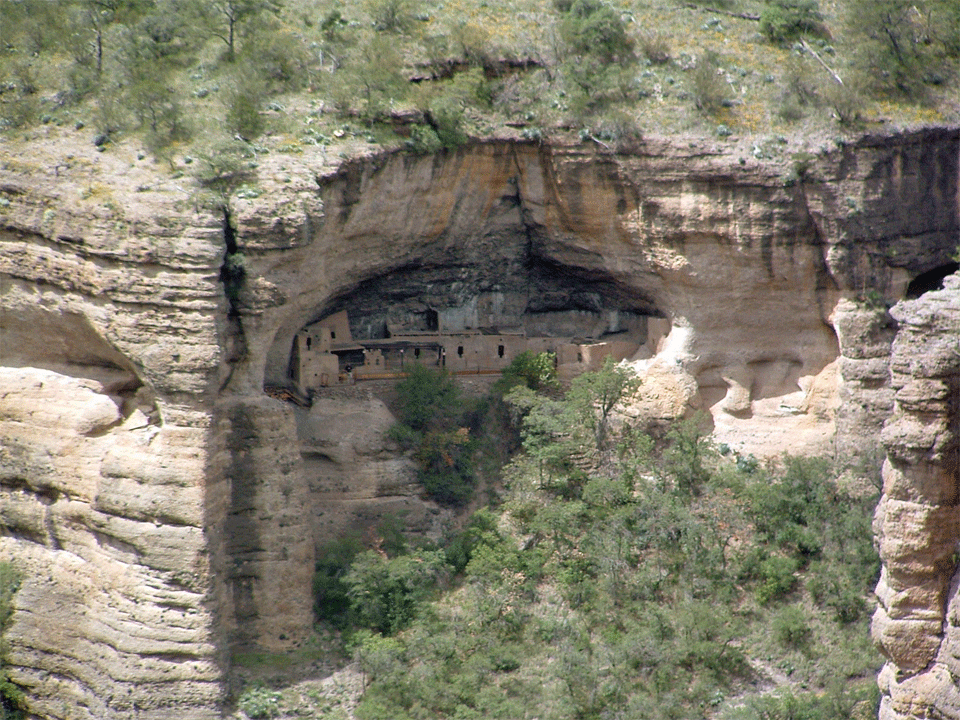
Main cave at Cuarenta Casas. Click here for source and more images.
David Phillips
Paquimé was the heart of the Casas Grandes culture, but it was one community among hundreds in a tradition that existed before the site, and that encompassed thousands of square kilometers.
Along permanent streams (in particular, the Rio Casas Grandes, Rio Santa Maria, and Rio Carmen), irrigation farming was the mainstay of the Medio perod. In higher valleys, terraces were placed along lower slopes and in valley bottoms to trap silt and runoff for "dry" farming (Di Peso 1974; Leubben et al. 1986; Schmidt and Gerald 1988). Elsewhere, the distribution of Medio period sites suggests a reliance on ak chin and other runoff techniques. The widespread dry farming done at middle elevations today is possible in part due to buffering of the high risks (for example, by resorting to migrant labor when a crop fails) and thus may not be an optimal analogue for prehistoric practices.
Sierra Madre Occidental
Medio period sites are common in the north end of the Sierra Madre Occidental, as far south as the upper reaches of the Rio Sirupa near Madera. Both open air sites and cliff dwellings occur, but the latter number more than 150 (Gamboa C. and Mancera-Valencia 2008:355) and have attracted the most attention. Medio period sites continue west into northeast Sonora, along the streams of the upper Yaqui drainage (Brand 1943:117).

Main cave at Cuarenta Casas. Click
here
for source and more images.
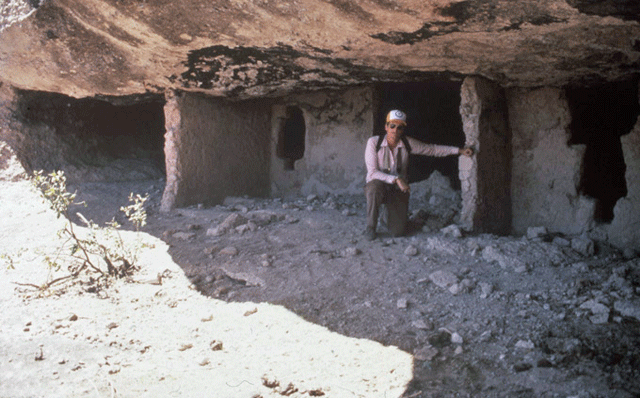
Lumholtz (1973) was the first to document the local cliff dewellings. The best known examples are Cuarenta Casas (remains in a series of caves; the largest is shown above) (Guevara S. 1984) and Cave Valley (Valle de las Cuevas) along the Rio Piedras Verdes (Guevara S. 1988; Lister 1958). The cliff dwellings have puddled adobe and jacal walls that include T-shaped doorways.
Some cliff dwellings had giant granaries like inverted ollas; the best preserved example is in Olla Cave (Cueva de la Olla) in Cave Valley, with an interior basal diameter of 2 m, a height of 3.6 m, and an estimated capacity of 15.5 m3 (Guevara S. 1988:16, 51). Lumholtz (1973) and Kidder (1936) documented a second fairly intact example. Elsewhere, the former presence of granaries is indicated by their ring-shaped bases (looters have destroyed large portions of these cave sites). The granaries were made of adobe or of coiled thick cables of grass, which were then daubed.

Medio period rooms in Cave Valley. Photograph by J. Ware.
Maxwell Museum Cat. No. 2007.80.507 (see end note).
Based on detailed architectural studies of the cliff dwellings, Elizabeth Bagwell (2006) concluded that much of the architecture is "homemade" rather than being strict clones of the buildings at Paquimé. Eduardo Gamboa argued that "the mountain dwellers were able to support themselves using locally available resources" including farm products and agave (Gamboa C. 2003:9). An ongoing project focused on the cliff dwellings nonetheless sees them as clearly part of the Casas Grandes world and further reports that "A communication system based on watchtowers and roads integrated the system regionally" (Gamboa C. and Mancera-Valencia 2008:363).
Northeast Sonora and Extreme Northwest Chihuahua
From the valleys of northeast Sonora (see, for example, Braniff 1986), Casas sites continue in a broad arc around the north end of the Sierra Madre. In Mexico, the Llano de Carretas ("Plain of Carts") extends west from the Rio Casas Grandes (at Janos) to the high passes to Sonora. This traditional wagon route was home to Carretas (unslipped) and Huerigos (slipped) Polychrome, both characterized by a fairly orange paste and by black paint that often has a subglaze appearance. Pottery designs usually follow the Babicora rather than Ramos tradition. The large sites found in this area (Brand 1943) indicate that this was a center of settlement in its own right.
The northeast Sonora Casas sites may have included ball courts (see Fish and Fish 2006:38) but if so, we need to distinguish between the Casas ball court system and a possibly different system tied into the Rio Sonora culture (Doolittle 1984).
Southeast Arizona, Southwest New Mexico
In the adjacent U.S., Medio period sites are assigned to the Animas phase, but the only difference is that the Animas phase sites are north of the border. Medio period sites occur both in southeastern Arizona and in the boot heel of New Mexico (Brand 1943; Fish and Fish 2006). Most of our current knowledge of the Arizona Medio period sites comes from the work of John Douglas (1987–2004). In New Mexico, multiple scholars including DeAtley (1980; DeAtley and Findlow 1982) have attacked the issue of the Medio period. In the U.S., Habitation sites are typically open air pueblos where floodwater farming could have been practiced. The size of the pueblos suggests that each supported many families, albeit total population of the boot heel area may have been about 1,000 to 1,500 (see Fish and Fish 2006:36). Variability in site size seems to relate to local agricultural potential rather than social differences (Douglas 1995).
At least four ballcourts were present at Animas phase sites (Fish and Fish 2006, Figure 3.9; Skibo et al. 2008). The local courts were of the parallel-sided type, and suggest almost a "sandlot league" level of social interaction. U Bar Cave (Lambert and Ambler 1961) provides a peek at more purely religious practices. The cave contained, among other things, a puebloan-style hunting shrine and fragments of scores of prayer offerings made from macaw feathers. (The feathers must have been obtained from Paquimé and other "core" Casas Grandes sites; they are not reported by Lambert and Ambler but were found by Curtis Schaafsma during emergency excavations in the cave.)
The dominant decorated pottery in Animas phase sites is Ramos Polychrome, which I suspect was mostly or entirely imported rather than locally made (but see DeAtley 1980; DeAtley and Findlow 1982). There is actually a gap in the distribution in Ramos Polychrome, which is common in the Paquimé "core area" and on Animas phase sites, but the intervening sites of the Llano de Carretas typically yield Carretas Polychrome (Carpenter 1992). In the Playas Valley the common utility type is Playas Red but in the Animas and San Bernardino Valleys it is Cloverdale Corrugated. In addition, Salado polychromes are more common in the Animas and San Bernardino Valleys. Finally, some of the western Animas phase/Medio period villages (on both sides of the border) are organized in terms of compounds (reminiscent of the Salado), while the eastern villages have more typically Puebloan layouts of straggling roomblocks defining plazas (Fish and Fish 2006:33–34). Douglas (2004:432–434) argues for the presence of a platform mound at the Pendleton Ruin (San Luis Valley). There seems to be spatial variability within the "Animas phase," possibly including greater penetration by the Salado religious movement in the more western valleys.
The general similarities in Animas phase versus "Casas core" pottery and architecture, along with the sharing of ceremonial items such as feathers, raises the issue of how tightly the Animas phase sites were integrated with the Casas Grandes "core." For Di Peso (1974), those sites were clearly subordinate to Medio period Paquimé, if not remnant populations that survived the abandonment of the culture's central town. Other scholars see the ties between the Casas "core" area and Animas phase sites as rather loose (DeAtley 1980; DeAtley and Findlow 1982; Minnis 1984, 1989).
Desert Lowlands of Northern Chihuahua
Along the west side of the Laguna de Guzmán, Brand (1943:132) found fishing camps with stone sinkers, albeit the lake does not always have enough water to support fish.
The Villa Ahumada area (lower Rio Carmen) was once considered part of the Casas Grandes culture, but recent excavation work suggest that the Villa Ahumada sites are beter considered part of the Jornada Mogollon culture of northeast Chihuahua, west Texas, and southern New Mexico.
West-Central Chihuahua
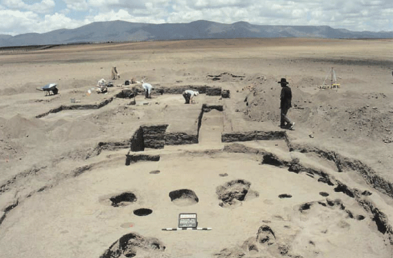
Di Peso's puchteca hypothesis might lead us to assume that as one travels closer to Mesoamerica, Casas Grandes sites show greater evidence of contact with that culture. The data indicate otherwise, however. Since 1990 Jane Kelley and her colleagues have studied the southern portion of the Casas Grandes culture area (which includes the Babicora Basin, the upper Rio Santa Maria and upper Rio Carmen. One site, Ch-272, may include a pre-Viejo (plainware) occupation but the evidence is ambiguous (Stewart et al. 1995:177–178). In contrast, a number of Viejo period sites are known for the southern zone and are locally dated from about A.D. 700 to about 1200 (Stewart et al. 2005). The Viejo sites extend to at least the Santa Ana area of the Santa Maria Valley (MacWilliams 2001:205–213; 293–294). The known southern Viejo period sites are hamlets of perhaps three to eight pit houses (Kelley et al. 2007); the hamlets can include a larger-than-usual pit house, as was the case at the Convento Site near Paquimé (and at many early Mogollon sites in the U.S.).

CH-254 under excavation by the Proyecto Arqueológico de Chihuahua
in 1999. The large "ceremonial" pit house is in the foreground. Image
used by permission of Jane Kelley.
During the later Viejo period, small amounts of Mimbres black-on-white pottery are found on sites (as is the case in such a broad zone on both sides of the international border). The southern Viejo period sites seem to have had access to exotic goods (most notably shell) that was as good as for the northern sites. At El Zurdo (Ch-159), remnants of a surface structure like Di Peso's Perros Bravos phase structures was found (Stewart et al. 2005:177). Otherwise, a local equivalent of the Perros Bravos phase—surface structures with Viejo pottery—is lacking. This absence of evidence is not conclusive, however, in part due to plowing that may have destroyed surface structures while missing deep pit houses.
The late Viejo period includes Santa Ana Polychrome, the immediate ancestor of the Medio period's Babícora Polychrome. Like Babícora, Santa Ana Polychrome designs were painted on smooth-walled vessels—in contrast to the textured polychromes characteristic of the late Viejo period in the Paquimé area.
Stable isotope analysis of human bone from local sites suggests that during both the Viejo period and the Medio period, "the main contributors to the diet were corn and beans, with animal resources of some importance" (Webster and Katzenberg 2008:94). Similarly, actual food remains include a mix of domesticated and wild plants, mostly small game, and turkeys (Hodgetts 1996). A bone fishhook was found at Ch-254 (Stewart et al. 2005:185–187). For those who equate expedient lithic technologies with decreased mobility, it is worth noting that analyses of Casas Grandes flaked stone invariably indicate expedient tool production (Juárez S. 2002; MacWilliams 2008; Rinaldo 1974; T. VanPool et al. 2000). The greater Casas Grandes area seems to be characterized by fairly sedentary and agricultural groups, with no fundamental changes in subsistence through time.
In the southern zone, the the dominant Medio period polychrome is Babícora, not Ramos, but sites have the massive adobe-walled architecture so common in northwest Chihuahua. For the most part, the southern zone seems to have held back from some of the changes so evident at Paquimé. Kelley and Burd-Larkin (2003) note that typical southern zone sites contain no more than three house mounds, and that public architecture is absent (but see below). They report only one copper bell from the southern zone, and add that turquoise and shell are uncommon. The southern zone seems to have retained a parochial flavor even as Paquimé consciously went cosmopolitan. Whatever specfic factors were behind Paquimé's changes seem to have skipped right over the southern zone, and today no one suspects Paquimé of having controlled the area. For detailed information on a small Medio period village of the southern zone, see Jane Kelley's (2008, 2009) reports on El Zurdo.

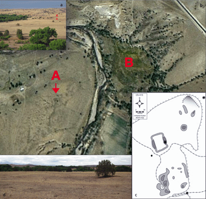
CH-315, Santa Clara Valley. (a) view to SW; (b) Google Earth
image with ballcourt (A) and wetlands (B); (c) sketch map; (d) view to
N, of ballcourt. Click on image to access original poster presentation
(Cunningham 2009, 1.1 MB).
Within the southern zone, thanks to recent work, a separate picture is beginning to emerge of the Santa Clara Valley. Residential sites are mostly Medio period, and it is not yet clear whether Viejo period components are common under Medio period ones as happens elsewhere. Sites appear to be near patches of floodplain near springs, and the only known ballcourt in the southern zone is at a residential site near Ciénega el Apache, a riverside wetland wtih multiple springs. Two fortified hilltops are present and may have been occupired during both the Archaic and Ceramic periods (Cunningham 2009). During the Medio period these agricultural sites would truly have been frontier settlements, with hunter-gatherers close by.
Photos with catalogue numbers copyright © Maxwell Museum of Anthropology, University of New Mexico. High-resolution versons of the photographs may be ordered from the Maxwell Museum's photo archives. Please make note of the catalogue numbers. For more information please visit the photo archives web page