
Ultimate Grand Canyon Backpack (Cont'd)
(Page 7 of 9)
 A Wilderness World trip led by Gary Casey met us for the last time. By this date all of their clients were clothed in rubberized rain suits except for the hearty boatmen. Perhaps their activity in oaring the boats, much like our hiking, kept them warm. We were extremely concerned about the adequacy of our clothing. We hadn't expected an early winter and for the first time we appeared to be underclothed. We now wore long pants each day instead of shorts. Our shirts and nylon jackets appeared insufficient to keep us warm whenever we were inactive so we took to wearing our sleeping bags in camp. We continued upstream past Unkar Delta, along river trails built by prospectors using the Tanner Trail, and eventually along the Beamer Trail to the Little Colorado. Only infrequent private parties were running the Colorado River this late in the season so we seldom saw a boat on the river. One day we passed another group of hikers coming downstream but never saw them. They probably observed fresh footprints as we did but in the large, sandy deltas below Desert View we passed each other unobserved. That evening, we camped by Lava Creek Rapid within a hundred yards of where this mysterious downstream group had camped the previous night.
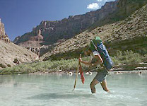
 The Little Colorado was not in flood, so the beautiful turquoise-colored water supplied by Blue Springs greeted us at the end of the Beamer Trail. The cool weather dissuaded us from swimming in this 60-70° F water but we took the time to wash and visit the Beamer cabin a few hundred yards upstream from the Colorado. Beamer was a prospector-hermit who had intended to farm the Little Colorado bench using a plow share that he brought with him. He built his cabin and cleared his trail but did not stay long, leaving few traces of his presence. Reputedly his cabin was built from an Indian ruin which was initially reported by Major John Wesley Powell. A mano and metate are still present near one wall of his cabin.
The cold days passed quickly as we moved through lower Marble Canyon. Fall had definitely arrived. We passed another group of hikers at Nankoweap Rapid but the 300 foot width of the Colorado made communication impossible. The cold weather apparently had reduced the power demands on Glen Canyon Dam so during the following days the river ran only a few thousand cubic feet per second, exposing large expanses of river bed. Our way from Nankoweap to Saddle Canyon was made significantly easier by this unique low water highway. Above President Harding Rapid, 20 miles of towering Redwall cliffs made hiking the Colorado's banks impossible. We once again had to leave the river and walk the cliff ledges. In this area, the limestone canyon walls take on a beautiful river polish, often becoming as smooth as marble. This inspired Major Powell to appropriately name this reach of the Colorado River, Marble Canyon.
[first page | previous page | next page | last page].
Updated on Thursday, November 3, 2011 @ 4:30 MST
© 1995-2011 by Robert R. Marley |