
Ultimate Grand Canyon Backpack (Cont'd)
(Page 8 of 9)
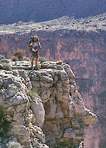 We were isolated from the river during this time with only one river access on a prehistoric Indian route across from the Bridge of Sighs. Again we carried a gallon of water each but the rainstorms of the prior week had left potholes in the limestone gullies full. Walking the top of the Redwall was relatively easy most of the time with the occasional steep gully crossing thrown in to keep us awake. Some of these steep side canyons cut several hundred foot hanging valleys into the top of the limestone, all of which had to be crossed or walked around. After a strenuous day we were able to reach the route to the river at the Bridge of Sighs. Arriving late that day, we met a small private boating party who had stopped to view both the Bridge and a small Indian ruin at the base of the Redwall descent route. They were surprised to see hikers in Marble Canyon and shared some beer and a large can of apple juice with us before departing for Buckfarm Canyon.
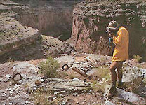
Continuing the next day, we passed the tram site above Redwall Cavern. Built in 1951, it and the Shinumo Wash horse trail were used to provision men and materials to this proposed dam site. Eventually the idea was given up and numerous artifacts remain to document the period. The more recent tram and dam site off Tatahotso Mesa was active in the 1960's. The advent of the environmental movement resulted in nearly complete eradication of all traces of this location both on the canyon rim and on the Redwall cliff tops below. The horse trail still exists along the Redwall rim to Shinumo Wash and we proceeded easily with the knowledge that a seven day food cache awaited us up this wash. My wife and I had backpacked in this last cache on a hot August day after Bob and I realized that commercial boat traffic would be non-existent by late October.
 This important final cache was still intact and Lee's Ferry now seemed within easy reach. While cold weather still prevailed, the knowledge that our goal was becoming increasingly achievable drove us onward. As the Redwall barrier layer on which we were walking receded below the river, bankside hiking again became possible near Cave Springs Rapid. Our route plan called for a crossing of the river at North Canyon where we knew that we might meet either an NPS trip or a naturalist study trip which were planned for late October. The NPS trip met us near 24 Mile Rapid, well below North Canyon, so after exchanging pleasantries we continued on to North Canyon without crossing. We rested and waited upstream of North Canyon for a day and eventually Larry Stevens, one of Wilderness World's regular boatmen, turned up with a Museum of Northern Arizona sponsored trip. This last crossing left us at the mouth of North Canyon with only 20 miles to go. The subsequent days were marred only by continuation of the bone-chilling cold and a couple of 30-40 foot vertical climbs with packs. About river mile six, we met Tom Workman, an NPS river ranger, who was on one of his infrequent downstream powerboat beach patrols. He agreed to relay a message to our ride that we would be finished a day early.
[first page | previous page | next / last page].
Updated on Thursday, November 3, 2011 @ 4:30 MST
© 1995-2011 by Robert R. Marley |