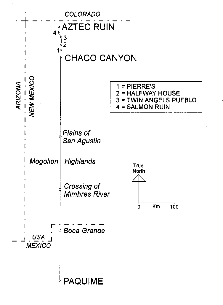
In 1999, Stephen Lekson gave Southwest archaeology one of its most stimulating books in years. In The Chaco Meridian he argued that three important prehistoric centers—Chaco Canyon, Aztec, and Paquimé—were consciously placed on the same degree of longitude (Figure 1). The process began, Lekson claims, with a "small and powerful elite" of perhaps 1,000 persons (Lekson 1999:96). About 1125, this elite moved away from Chaco Canyon in response to drought or some other disaster (Lekson 1999:64), to a new capital at Aztec Ruin, about 88 km to the north. The Chaco elite abandoned Aztec 150 years later, again due to drought, and established a third capital about 630 km south of Chaco Canyon, at Paquimé (Lekson 1999:96). "Aztec replaced Chaco and, in its turn, was replaced by Paquimé" (Lekson 1999:110). The riveting part of the argument is Lekson's claim that as the Chaco elite moved south about 1275, they used their engineering skills to ensure that their new political capital, Paquimé, was on the same meridian—despite being hundreds of kilometers south of Chaco Canyon.
Lekson's argument is novel, provocative, and wrong. Beginning with a single idea, Lekson has scraped together all the information that supports the idea, much as fictional police inspectors build their case against a suspect. I don't deny Lekson's right to advocate an idea but archaeology is better served when each author is also his own worst critic. This has not happened in The Chaco Meridian so I will attempt to clear the accused, the Chaco Canyon elite, of having established Paquimé (which I view as Mogollon, not Anasazi). I cast myself as the amateur sleuth who, finding himself at the fatal dinner, decides to help the inspector.
Lekson admits that his work on the Chaco Meridian began with a simple but startling observation: the site of Paquimé is due south of the center of Chaco Canyon (Table 1), despite the roughly 630 km distance between them.[1] Lekson sought to determine whether the shared meridian was a coincidence or had a cause. Given architectural and other parallels between Chaco and Paquimé, Lekson concluded that the two cultures were directly linked despite the distance and years separating them. Lekson also hypothesized a mechanism for this link: an elite that shifted its power base whenever an old location became uninhabitable. "The shifting center was not necessarily a harbinger of larger migrations.... The key sector was that small elite, decision-makers who perpetuated their power through architectural and landscape symbolism, a few hundred elites and their retainers" (Lekson 1999:141).
To prove his hypothesis, Lekson turned to the three lines of evidence used in detective novels: means, motive,and opportunity. To begin with, could Chaco's engineers could lay out a north-south line of such precision? Lekson's smoking gun is the North Road, which on a small-scale map (such as Figure 1) extends due north from Chaco Canyon to the San Juan Valley (see also Lekson 1999:Figure 4.1; Lekson et al. 1988). Hence, he concluded, the Chacoans had the means. Lekson also sought evidence that the Chacoans were compelled to align major centers along a meridian. He did this by arguing that a "New Chaco," known today as Aztec Ruin, was consciously placed north of the original capital in Chaco Canyon. Armed with evidence that the Chacoans were "meridian compulsive," Lekson had established a motive. The final problem was explaining how Chaco Canyon's elite could have survived to found a new regional capital at Paquimé, after "going out of business" at Chaco over a century earlier. Again, Aztec Ruin was critical to the argument; Lekson claimed that when the Chaco elite left Chaco Canyon about 1125, they holed up at Aztec until departing for Paquimé about 1275. Means, motive, opportunity. Inspector Lekson assures us that the case is closed.
But is it? In the tradition of detective novels, let us examine his evidence.
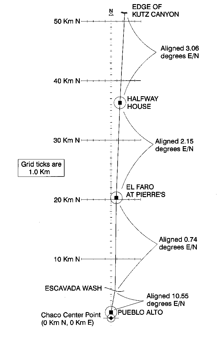
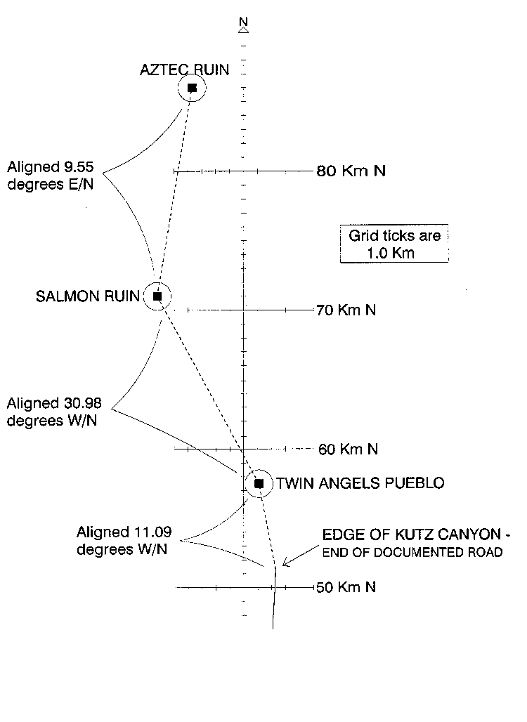
Lekson's assurance that the Chacoans could survey precise north-south lines over great distances is based on the North Road (1999:117), which extends from Pueblo Alto (just outside Chaco Canyon) to the edge of Kutz Canyon (part of the San Juan Valley; Figure 2). Most Chacoan roads were short bits, more ritual than functional (Roney 1992), but the North Road was continuous or nearly so (Obenauf 1980; Kinkaid 1983). The North Road was built "no earlier than the 1080s and more likely the early 1100s" (Lekson 1999:115; based on Stein and McKenna 1988:57). At Kutz Canyon the road extended down a sloping ridge crest, reaching the canyon floor by a series of wood platforms (Marshall and Sofaer 1988:121–123). At that point, however, the known road ends. Lekson assumes that heavy erosion in Kutz Canyon has erased the road and projects it to Twin Angels Pueblo (an isolated Chacoan structure within the canyon) and on to Salmon Ruin and Aztec Ruin (Figure 3). "Whatever the methods used," he remarks, "Twin Angels Pueblo is less than 1 [minute] off the longitude of the North Road where [the road] begins its meridian route at Escavada Wash—an error of less than 500 m over a length of more than 55 km" (Lekson 1999:118).
How much of that precision is a matter of engineering, as opposed to accident? Lekson (1999:117–118) cites a different occasion on which the Chacoans surveyed with errors of less than 1 degree: the relative placement of Pueblo Bonito, Hungo Pavi, and Tsin Kletsin. He states that based on field experiments using Neolithic technology, "lines could be prolonged over broken terrain with ... about 1 m of error over 2 km" (Lekson 1999:118). Finally, he states that the error of angle for Chacoan alignments based on long-term celestial cycles was usually no greater than 2 degrees (Lekson 1999:119), but such alignments may have been less accurate than other Chacoan measurements due to "their much longer observational cycles" (Lekson 1999:117–118). In other words, Lekson accepts 2 degrees as the maximum error of angle for Chacoan alignments (1999:122–123). For the remainder of this discussion I will also accept 2 degrees as the maximum error of angle in Chacoan surveying.
Having established that the Chacoans had the means to survey a straight north-south line, Lekson must establish their motive for surveying such a line from Chaco south to Paquimé. Lekson argues that the Chacoans were compelled to establish their successive capitals on a single meridian, defined by the center of their first capital at Chaco Canyon. When the time came to leave the San Juan Basin, Lekson tells us, the Chacoans laid out a new line from the Chaco Canyon spiritual datum southwards—following it 631 km over mountains and deserts, sometimes cutting their way through forests, until they encountered the Casas Grandes Valley. If it happened as Lekson describes, the southward migration would easily qualify as the most compulsive act in Southwestern prehistory. How does Lekson know that the Chacoans were so "meridian compulsive"?
Lekson cites the "fact" that the Chaco elite had completed such a migration once before, from Chaco to Aztec. [2] It's easy to argue that after 1110, Aztec was becoming a capital inspired by the one in Chaco Canyon. Between 900 and 1100, Chaco Canyon had developed a highly formal structure, including a "center place" flanked by great houses exactly to the north (Pueblo Alto), east (Chetro Ketl), south (Tsin Kletzin), and west (Pueblo Bonito; Lekson 1999:Figure 3.7; based on Fritz 1987). In this case at least, the cardinal directions were important to people in Chaco Canyon. Similarly, Aztec has a "center place" flanked by great houses to the west (the ruin developed for tourists), east, and north (Lekson 1999:Figure 3.6; based on McKenna and Toll 1992 and Stein and McKenna 1988). The Aztec "capital complex" is not aligned to the cardinal directions but otherwise the similarities are intriguing. Given two successive Chacoan capitals that resemble each other in layout, one exactly north of the other, the argument for "meridian compulsive" behavior would be difficult to deny.
Aztec is not due north of Chaco, however (Table 1 and Table 2), as Lekson (1999:70, 113) admits (but see Lekson 1999:86). Aztec is 3.7 km west of the Chaco Meridian, over a north-south distance of 86 km, which is an angle of 2.5 degrees west of north (Lekson 1999:117). Thus, Aztec's placement off the Chaco Meridian cannot be attributed to survey error alone. Nor was this "deviation" due to practical necessity: the Chaco Meridian crosses the Animas River in an area of prime farmland. The spatial relationship between the two sites is evidence against meridian compulsion, not for it.
Our police inspector admonishes us that "the Chaco Meridian was a constructed feature, not a geodetic line" (1999:113)—but in that case the discrepancy is even greater. Our nearest verifiable point of reference on the "as-built" meridian is where the North Road drops into Kutz Canyon; the center of Aztec is 34.7 km north and 6.0 km west of that point, or 9.9 degrees away from where it should be (Table 2). Whether one measures from Chaco Canyon or the known end of the North Road, Aztec is on a different meridian.
Faced with this flaw in his theory, our police inspector extemporizes. While the North Road extends north from Escavada Wash to Twin Angels Pueblo, it also includes (he claims) a dogleg that begins at Twin Angels and ends at Salmon Ruin, a large Chacoan village established on the San Juan River about 1088 (Figure 3; Lekson 1999:Figure 2.5, 76, 115–117). Why a dogleg, among such compulsive people? Inspector Lekson claims that the terrain in Kutz Canyon forced a change in direction once Twin Angels Pueblo was reached. "These people were not idiots," Lekson (1999:117) tells us; in the Kutz Canyon rugged "moonscape" they altered their course. But stupid is as stupid does; the Chacoans responded to the terrain after traversing 6.3 km of Kutz Canyon, on a bearing that was 11 degrees too far to the west (Table 2). Had the Chacoans extended the North Road north through Kutz Canyon, they would have been through the "moonscape" after 12.5 km; the claimed labor-saving dogleg increases the total distance through those badlands to 15.0 km. I agree with Lekson, the Chacoans "were not idiots," so there is something wrong with the North Road "dog-legging" out of necessity. Perhaps it was a matter of choice. [3]
The amateur sleuth finds support for this assertion from the opposite end of the North Road. The start of the North Road also has a substantial bend, in gently rolling terrain. "The North Road ... begins at Pueblo Alto [at] Chaco Canyon and runs at about 15 [degrees] east of north 3 km to Escavada Wash. At the Escavada, the road corrects its course and runs north" (Lekson 1999:115). Actually there are two bends in that short distance, but the overall alignment of the road between Pueblo Alto and Escavada Wash is 11 degrees east of north (Table 2). A deviation of that size must have been deliberate, not accidental, and in the terrain between Pueblo Alto and Escavada wash it was voluntary. Thus, at least two important legs of Lekson's North Road are aligned substantially off north-south, and in at least one case the shift was clearly a matter of choice.
Between Escavada Wash and Pierre's Ruin, the North Road lives up to its name: at the end of 15.5 km it is only 200 meters "off course," an error of angle of less than 1 degree.[4] But chez Pierre something happens; the road veers 2.1 degrees east of north. This is barely more than the stated "maximum error" for Chacoan surveying, but the orientation is maintained consistently over 16 km to Halfway House so the Chacoans must have been aware of it. Beyond Halfway House the "skew" actually increases; from there to the drop-off into Kutz Canyon, the road is consistently aligned 3.1 degrees east of north.
Let's take another look, then, at our supposed exercise in compulsion. Of the 50.3 km north-south distance traversed by the North Road between Pueblo Alto and Kutz Canyon, by Lekson's standards 15.5 km are north-south and 34.8 km are not. More than two-thirds of the North Road is not a north road! If the road once extended to Salmon, as Lekson argues, more than three-quarters of the North Road fails to live up to its name. Lekson's own evidence indicates that the Chacoans' north-south compulsion, so necessary to his theory, did not exist. [5]
This fact, damaging as it is, does not faze our eager inspector. Being at the end of the "not-so-North-Road" means that Salmon is conceptually north of Chaco even if it is not physically north of Chaco (see Lekson 1999:114–115). But wait, the amateur sleuth exclaims. The whole case for a Chaco-Paquimé connection rests on an assumption that the Chacoans were so compulsive about north-south lines that deviation was not allowed—yet in going from Chaco to Salmon, deviations are common.
Faced with this discrepancy, our police inspector again extemporizes. Aztec is not physically due north of Chaco, but once at the San Juan River the Chaco engineers used a new starting point, Salmon Ruin. Lekson repeatedly claims that Aztec is "due north of" (1999:Figure 2.5, 129; 159) or "precisely north" (1999:117) of Salmon. In other words, although the Chacoans fell off the meridian wagon before they arrived at Salmon, once there they resumed their vow of constancy. Lekson is so sure of the north-south relationship between Salmon and Aztec that he claims that the North road must extend from the former to the latter, even though "this segment has not yet been located on the ground" (Lekson 1999:117). [6]
Actually, it doesn't matter whether there's a road between Salmon and Aztec, at least for this analysis, because Aztec is not due north of Salmon (Table 1 and Table2. The center of Aztec (defined as the Mound F tri-wall structure; Lekson 1999:113) is 2.5 km east of the center of Salmon Ruin, over a north-south distance of 15.0 km. Any road from Salmon to Aztec was not aligned due north but 9.6 degrees east of north, well outside Lekson's 2 degree tolerance range for Chacoan surveys. In other words, a key fact in Lekson's argument—the north-south alignment between Salmon Ruin and Aztec Ruin—is wrong.
In summary, Lekson's version of the North Road—from Pueblo Alto to Aztec Ruin—is aligned to a meridian (not the Chaco meridian) for 16 out of 80 km. For the rest of the distance, the North Road demonstrates the Chacoan ability to avoid being compulsive. Yet this is the road that "proves" the Chacoan compulsion to survey a 631 km line due south, over some of the most rugged country in New Mexico.
Writers of detective novels always need to stretch out their story, and the easiest way to do this is to spin subplots. I'm not ashamed to use the same device. Before we turn to "opportunity" we will visit crime scenes not yet examined. According to Lekson, when the "New Chaco" at Aztec failed, the Chaco elite loaded the kids into the family burden basket and began moving—this time south.
("'Bring what?' [asked Pooh]. 'Things to eat,' [said Christopher Robin]. 'Oh!' said Pooh happily. 'I thought you said Provisions'" [Milne 1992:113].)
Lekson requires us to believe that 1,000 men, women, and children undertook a 717 km "expotition" from Aztec to Paquimé, not as quickly as they could walk but carefully establishing a survey line as they went. These were, furthermore, an elite fleeing the collapse of their society, so they did this without their traditional means of support, across country that in places was deserted or nearly so. From Aztec Ruin to Chaco Canyon the trip went as quickly as any march with children could, thanks to the North Road. By pushing, they may have made that march in, say, five days. There they began establishing a strict meridian line to guide their travel. Let's assume that they were able to survey the new line at an average rate of 5 km a day—which is generous, considering the precision being maintained and the terrain to be crossed. To cover the 631 km between Chaco Canyon and Paquimé, the Chaco elite would have been traveling about 125 days. Including the sprint from Aztec to Chaco, this was a journey of about 130 days.
Lekson is aware of far one can carry a food supply; those limits have figured in past debates about Chacoan society (Drennan 1984; Lightfoot 1979; both cited by Lekson [1999:46]). Based on Lightfoot's study, let's assume that each person in Lekson's 1,000-member hegira carried a 25 kg load, of which 24 kg was mealed corn (see Lightfoot 1979). Doled out with extreme care, this was a roughly 50 day supply of food.
The Chacoans could have supplemented their cornmeal with wild foods, of course—but this was a mob on the move, unfamiliar with local resources, so I will concede one day's wild food for every five carried from Aztec. Also, Lekson claims that as the Chacoan elite traveled southward the local villagers, overawed by this visit from a legendary elite, would have fed them (1999:139–140). Let's factor in such a possibility, and assume that for every four days of carried, hunted, or gathered food, the Chacoans gleaned one day's food from awe-struck local villagers (or following Turner [1998], they simply ate the local villagers). In that case, the Chacoan elite would have run out of food after 75 days—or 55 days before arriving at Paquimé.
Lekson assumes that the trip should be measured in years, however, not in days. He asks us to imagine "a major, memorable" (only no one remembers it) "event [that] required coordination over large areas and considerable time—perhaps decades" (Lekson 1999:140). Lekson's culinary deus ex machina is the bedazzled local villagers, who (Lekson assures us) opened up their granaries to the passing group. Let's assume, then, that the southward procession took half a decade and that the food came from local villagers. In those five years, Lekson's select 1,000 would have consumed, say, 500 grams of food per person per day. This works out to 500 kilos of food a day—and the honored guests weren't exactly eating and running, given their average daily survey rate of less than 350 m. If the villages so honored were spaced 10 km apart, each village would have had to pony up over 14 metric tons of food. Yet we're expected to assume that the villagers in the next valley waited eagerly, hoping that they, too could be forced into starvation by a quondam elite. I find this vision so unlikely that I will stick with the next least likely option: the Chacoans left home with as much food as they could carry.
Moving south from Chaco Canyon, the erstwhile lords of Aztec could have sped their journey on one of the few undoubted Chacoan highways: the South Road (Lekson 1999:Figure 2.8; Nials et al. 1987). This road extends west of south (Lekson 1999:114–115), not due south—but if the North Road is a meridian line so is the South Road. Lekson's Chacoan elite ignored that road, however, laboriously establishing a survey line due south from Chaco Canyon, adding many days to an uncertain journey with a limited food supply. Perhaps; but at this point the amateur sleuth can't help remarking on a pattern in the inspector's logic. When precision hurts the inspector's case (the Chaco-Aztec connection), he accuses the Chacoans of being sloppy in their compulsions; when precision helps his case (the Chaco-Paquimé connection), Lekson claims that the Chacoan were utterly precise.
As Lekson admits, his great southward migration led the Chaco elite into the Mimbres Valley, a place that had once supported a large, thriving agricultural community (Figure 1; Lekson 1996:Fig. 4.2). As they stopped for the night at the Mimbres River, the Chaco elite had been traveling some 75 days and were down to their last meal. Here was an irrigable valley on their sacred meridian; what better place to stop? Instead, the Chacoans tightened their sashes another notch and marched into the desert.
Why didn't they stop? "That nest was fouled," Lekson explains (1996:137); it was a "despoiled" country (1996:160). But using one of Lekson's end dates for the Mimbres phase, A.D. 1130 (Lekson 1996:136), and assuming that the Chaco elite arrived soon after they left Aztec, about A.D. 1275 (Table 3), the Mimbres valley had been recovering from the heavy Mimbres occupation for 145 years. What Neolithic, non-pastoral, non-state economic activity would so "foul" the Mimbres valley that seven generations later, it was uninhabitable?
Still, Lekson assures us, the Chacoans turned up their nose at the Mimbres Valley and surveyed on into the desert—perhaps eating their burden baskets, as by this point there was nothing in them.
Some 103 days out of Aztec, and some 28 days after running out of food, the Chaco elite found their promised land: they reached the Rio Casas Grandes at Boca Grande.[7] If the Chacoans were hungry by the Mimbres Valley, they were desiccated scarecrows by this point. A group acting under an ordinary compulsion might have declared the journey officially over. Not Lekson's Chacoans; they chose to work their way 19 km up the floodplain of the river, sometimes clearing their survey line through cottonwoods.
At Rancho Nuevo, north of Asunción, the survey line left the floodplain of the Rio Casas Grandes, returning to the open desert. A group acting under an ordinary compulsion might have taken the hint that it was time to quit. Lekson's Chacoans hadn't noticed, however; they continued into the desert. Fortunately for them, two weeks and 73 km later (at Corralitos) they again reached the Rio Casas Grandes. Certainly this time, someone would have noticed. Not Lekson's Chacoans; instead they worked their way an additional 39 km up the fertile Rio Casas Grandes floodplain, looking for a place to farm. Finally, when the line left the floodplain for a bit of high ground, the Chacoans stopped and established Paquimé. No doubt because the metate carrier snuck up behind the expedition's leader, and brained him.
Lekson claims that before his Chacoan elite arrived, the Casas Grandes Valley was "an empty niche, ripe for major canal irrigation" (Lekson 1999:172). He also describes it as a "previously unimportant" and "sparsely populated valley" (1999:132, 141). "Paquimé was essentially de novo" (1999:136). If we need to explain the founding of Paquimé, however, we can assume that the existing residents had something to do with it. The sedentary occupation of the valley dates from the Archaic period (Hard and Roney 1998). Before the Medio period the valley was occupied by a Viejo period Casas Grandes population, whose sites included the location of Lekson's new Chacoan capital (Di Peso 1974; Di Peso et al. 1974). Moreover, the roots of the Medio period can be found in the late Viejo period (Whalen and Minnis 2001:137, 196–197).
Viejo sites are found from the mountains to the lowlands, but more than 70 percent of them lie in the well-watered valleys of the region's major streams. Present data also indicate that (a) some large communities had begun to form in the study area by late Viejo times, or after about A.D. 1000; and (b) there may have been expansion of Viejo period populations out of the major river valleys and into upland areas, most likely in the latter part of the Viejo period. The settlement pattern of the late Viejo period, then, seems to presage that of the succeeding Medio [Whalen and Minnis 2001:137].
Lekson's Aztec-to-Paquimé migration depends heavily on the murkiness of Casas Grandes chronology. In Lekson's scenario, Medio period Casas Grandes culture sprang up when the Chacoan elite arrived. He writes, "The principal question of Casas Grandes archaeology, in my opinion, is the nature of the area's population between the end of the Mimbres phase (about 1130) and the beginnings of Paquimé (between 1250 and 1300)" (Lekson 1999:136). Lekson immediately answers his own question, however, stating that "Whalen and Minnis (1996) have been looking for post-Mimbres, pre-Paquimé sites for a decade, without a great deal of luck." On the same page he asserts that "There is thin evidence for significant populations immediately prior to Paquimé."
Lekson's arguments depend, however, on a selective reading of Dean and Ravesloot's (1993) article on tree-ring dates from Paquimé. None of the tree-ring samples from the site yielded a cutting date so Dean and Ravesloot devised a computer-based protocol to date the samples. Still, the dates are estimates, and the resulting Paquimé chronology lacks the precision usually attributed to tree-ring samples. Dean and Ravesloot (1993:97) suggested that the Medio period began between 1200 and 1250 (1993:97). Lekson sometimes takes that as license to push the start of the Medio period to between 1250 and 1300, but more often dates that event to the upper limit of Dean and Ravesloot's range (i.e., 1250; Table 3). It is possible to push the start of the Medio period the other way, however. Five estimated cutting dates at Paquimé fall before A.D. 1200 and almost one-third of these dates fall before 1250 (Dean and Ravesloot 1993:93, Fig. 6.4; 96). While "the actual dates of tree felling are likely to be later than the estimates" (1993:93), Dean and Ravesloot's upper limits for several samples fall before 1250. Taken together, these data suggest that the Medio period began before 1250. Since the Dean and Ravesloot article appeared, one of its authors has summarized the results as placing the Medio period "between A.D. 1200 and 1450" (Ravesloot 1998:122). Based on a combination of techniques, including the revised tree-ring estimates and ceramic cross-dating, I find it most plausible to date the start of the Medio period to ca. 1200 (see Phillips and Carpenter 1999:80; Schaafsma and Riley 1999:7, Table 1).
This digression on chronology helps establish an important objection to Lekson's scenario of an "empty niche" along the Rio Casas Grandes. If the Medio period (post-1200) follows hard on the heels of the terminal Mimbres occupation (pre-1200; see Nelson 1999 and Hegmon et al. 1999), we would not expect Whalen and Minnis to find any "post-Mimbres, pre-Paquimé" sites (Lekson 1999:136) because no such period exists. The evidence from the Casas Grandes area is limited but it is more consistent with Mimbres-Casas continuity (with, at most, a time of turmoil after the Mimbres collapse) than with an "empty niche" followed by a Chacoan invasion. Let us not quibble, however; let us accept Lekson's oft-repeated 1250 starting date for Medio period Paquimé, and see where it leads us.
Once arrived at Paquimé, how did the Chacoan leaders replicate their earlier capitals? In the late 1200s, other emigrants from the Four Corners took their pottery-making habits with them, but there is nothing to suggest an injection of Four Corners pottery styles in the local Casas Grandes ceramic sequence. Lekson defends the lack of Anasazi impact on Casas pottery because "Chaco-Aztec-Paquimé was not a migration, nor a folk movement, it was an elaborately staged shift in a ceremonial city, directed by elites who show themselves, archaeologically, in different ways than nonelites" and that "Elites manifested themselves in architecture and exotica, not serving dishes" (1999:96). He tells us that the Chacoan leaders instead "perpetuated their power through architectural and landscape symbolism" (1999:141).
Let's assume he's correct; does Paquimé resemble Chaco and Aztec in terms of basic layout? Not in the slightest. Chaco and Aztec consisted of widely spaced buildings positioned at quarter-turns around a "center space"; in Lekson's view, Paquimé consisted of two closely massed main buildings and a halo of lesser structures. [8] Lekson explains this away by noting that Puebloan village layout changed through time, but we are not talking about village architecture here, we are talking about elite architecture—and the members of this elite "perpetuated their power through architectural and landscape symbolism" (1999:141). By Lekson's own logic, the fundamental difference in layout between Chaco-Aztec and Paquimé tells us that the latter was not created by a Chacoan elite.
Lekson (1999:87–101) also lists numerous architectural details and items of material culture and shared by Chaco and Paquimé. Many of the architectural details and items of material culture occur widely in the North American Southwest (e.g., Lekson 1999:100–101), so their presence at Chaco and Paquimé adds nothing to the argument for an exclusive relationship between the two areas. Roads, for example, occur in the Hohokam area (Motsinger 1998; Wilcox et al. 1981) as well as in the Chacoan and Casas Grandes areas, as Lekson (1999:67) admits. Rather than play the shared-trait game, however, let's remember why that approach keeps falling out of favor. Lists of shared traits have the inherent bias of stating what two areas had in common, without examining the ways in which the areas differed. Chaco Canyon and Aztec had circular great kivas; Paquimé did not. Paquimé had many rooms with unusual floor plans (such as zig-zags and crosses); Chaco and Aztec did not. Paquimé had ball courts; Chaco and Aztec did not. Paquimé had a domestic water system and stone-lined drains; Chaco and Aztec did not. And so on, and so on; if we play the trait-list game, in architectural and any other terms Paquimé is more unlike Chaco and Aztec than it is like them. We are left with a Chacoan elite who created an obvious copy of Chaco at Aztec, but were unable to do so at Paquimé.
This bring us to opportunity, which I have saved for last because bringing it up sooner would keep me from stretching out this story. Let the Chacoans carry two burden baskets apiece; let them be the biggest moochers in prehistory; let them live off Swiss bank accounts; they could not have made the trips Lekson describes. When Lekson first postulated a connection between Chaco and Paquimé, opportunity was a serious challenge: Chaco Canyon had collapsed about 1125 and Paquimé had not begun (he believed) until about 1250—which left more than a century between the Chacoans' leaving one place and arriving at the other. Unless he could explain where the Chacoans had been all those years, his case would fall apart. "Long after" noticing the original connection, Lekson concluded that Aztec Ruin was the temporal bridge (Lekson 1999:17, 73). The Chacoans left Chaco Canyon for Aztec, and then left Aztec just in time to be responsible for Paquimé.
Unfortunately, Lekson filled the 125-year gap between Bonito phase Chaco Canyon and Medio period Paquimé rather too well. If Lekson's dates for the successive Chacoan capitals are correct, the Chaco elites left their home canyon about A.D. 1125 and arrived at the Animas River and began building Aztec about A.D. 1110—15 years before they left. Fast travelers indeed. They still had this knack when forced to leave Aztec about A.D. 1275; by Lekson's own reckoning, after traveling for years, "perhaps decades" (1999:140) they arrived at Paquimé about 1250, a quarter century before they left. This, by the way, must explain how they fed themselves on the long southward journey. Traveling backwards through time, they ended with more food than when they began.
The whole scheme is less absurd if one accepts that Salmon Ruin and Aztec Ruin were intentionally established before Chaco Canyon was abandoned, and that Paquimé was established before Aztec Ruin was abandoned.[9] Not a critical point, however. If we assume that Lekson's overlapping dates are evidence of planning, we are giving up Chacoans who traveled into the past for Chacoans who saw into the future. About 1110, the Chacoan elite responded to the collapse of their original capital by establishing a new one at Aztec Ruin—even though that collapse was 15 years in the future. The Chacoans pulled off this trick again: by 1250 they had laid out an incredibly difficult survey line from Chaco Canyon to the Rio Casas Grandes, and had started building their new capital, 25 years before the Great Drought would force them to leave the San Juan drainage.
Remarkable foresight. Or, perhaps, what the dates really tell us is that Salmon, Aztec, and Paquimé were founded without reference to the comings and goings of a single elite. I suspect as much, because the Chaco elite could not have picked up and moved as Lekson describes, unless they could either visit the past or see the future. The Chaco elite had the means but they lacked the motive and now, it turns out, they also lacked the opportunity.
Like other detective stories, this one includes a "wrap-up" to help the reader with the loose ends. As we sit about in our smoking jackets or full-length gowns, let's go over the flaws in the theory advanced by the eager (and in this story, much-liked) police inspector. He argues that after Chaco Canyon itself there were two "subsequent" Chacoan capitals, Aztec and Paquimé. He asks us to believe that the Chaco elite was utterly compulsive about locating its subsequent capitals along the same meridian as the original Chaco—but one of the two subsequent capitals was placed off that meridian. We know that the Chacoans could have surveyed the necessary lines, so it follows that in establishing Aztec the Chacoans didn't care whether that site was aligned with Chaco. If all three of Lekson's capitals lined up, the pattern would be undeniable; if only two lined up (and there is always a line between two points), coincidence again becomes possible. The Chacoans had the means, but apparently not the motive.
Besides, they didn't have the opportunity. To shift their capital from Chaco to Salmon, and then Aztec, and then to Paquimé, the Chacoan elites would have had to leap (or see) back and forth through time, not just through space. Aztec began developing years before Lekson's elite bailed out of Chaco, and Paquimé began developing years before that hypothesized elite bailed out of Aztec. To the degree that all these places had linked histories, the connecting thread was not an itinerant elite.
Still, let's not unthinkingly defend the null hypothesis. If, despite being over 600 km apart, Chaco Canyon and Paquimé were on the same meridian and shared patterns of exclusive cultural traits, it would be safe to conclude that the meridian had cosmological significance. In fact, Chaco and Paquimé are no more like each other than we would expect for any two major centers in the North American Southwest. Coincidence continues to be the most likely explanation for the north-south alignment of Chaco and Paquimé.
At this point, we can ask how our police inspector went off the track. To answer this, though, I must expound on matters statistical, guaranteed to put every reader of detective novels—and many archaeologists—to sleep. But it is an important issue, so I'll risk it. Let's assume that the Chacoan surveyors could lay roads (visible or invisible) in any direction from a given starting point, with the sort of accuracy implied by Chaco and Paquimé's shared meridian. Under a "random" process the odds of a road using a particular orientation (measured to the nearest whole degree) are one in 180,[10] which is 0.56 percent. If Lekson had come up with a theory that stated that some major center in the North American Southwest would be due north or south of Chaco, and then found that Paquimé fit his prediction, he would have predicted an event that by chance alone would happen only six times in a thousand. Note, however, that Lekson noticed the alignment first, then developed his theory to explain it. In other words, he did not explain an event whose probability was otherwise less than 1 percent, he explained an event whose probability was otherwise 100 percent. Given this logical order, the "improbability" of the shared meridian is a statistical illusion.
To put it another way, sometimes no explanation is needed even if an event is unlikely by chance alone. Consider that the documented footprint for the North Road extends undeniably, exactly, precisely from Pueblo Alto to the Bureau of Land Management restrooms at the edge of Kutz Canyon. Given the known distribution of BLM restrooms, the probability of this happening by chance is one in a zillion. As much as Chacoan travelers would have appreciated the BLM facilities, no one feels obliged to explain the alignment. Coincidence happens. [11]
The reader may insist: "Yes, but: did coincidence happen this time?" I'll therefore point out that consistent with the highest canons of scientific thinking, Lekson tested his initial theory against an independent set of data. After Lekson noticed the Chaco-Paquimé alignment he extended that alignment northward, on the assumption that any other important regional capitals would be also be on the same longitude as Chaco. Lekson identified an additional alleged Chacoan capital, but within the limits of Chacoan engineering it was not where it should be. Lekson seems unaware of the statistical independence of this test of his initial observation, or that according to that test,the coincidence that sparked his entire book is, in fact, only a coincidence.
This essay is based on a poster presentation at the 65th annual meetings of the Society for American Archaeology. Travel support was provided by SWCA Environmental Consultants. Thanks to Larry Baker, Judith Gregory, John Kantner, Bill Lipe, Joan Mathien, Gretchen Obenauf, Heidi Reed, John Roney, Lynne Sebastian, Alan Shalette, Christine VanPool, and Todd VanPool for opportunities to bounce ideas (or drafts of this paper, or both) off them. Thanks also to Rolf Sinclair and a second, anonymous reviewer (Curt Schaafsma) for American Antiquity, for their useful comments. Last but definitely not least, thanks to Steve Lekson for forcing me to think about things I had taken for granted.
1. Table 1 includes exact locations of four well-known sites in actively managed reserves. For other points, Table 2 provides locations in terms of a Cartesian grid whose origin is the Chaco Canyon "center place." The data are accurate enough to use in evaluating Lekson's hypothesis but contain enough error to conceal the exact locations of unprotected sites.
2. Lekson argues, in passing, that Aztec was actually the second attempt to establish a Chacoan capital north of Chaco—the first, unsuccessful attempt being at Salmon Ruin (Lekson 1999:Figure 2.5, 159). This assertion is not critical to his arguments or mine so for the sake of the reader, I will bypass that twist in the plot.
3. I doubt the existence of these doglegs (the plural is correct; the road would have veered twice, at the edge of Kutz Canyon and again at Twin Angels Pueblo). The Twin Angels to Salmon dogleg shows up on numerous maps as a projected route, but no one has found the road despite multiple examinations of aerial photographs and the actual terrain. The topography of Kutz Canyon is so rugged that once northbound travelers reached the floor of the canyon, they probably made no attempt to follow a linear route in any direction. Marshall and Sofaer (1988:119-121) remark:
[V]arious research projects ... have made the assumption that the roadway continued at an angle change to Twin Angels Pueblo and [then followed] the eroded floor of Kutz Canyon on to the Salmon Ruins. This presumption has no basis other than locational proximity. It is largely based on the belief that Chacoan roadways were constructed solely to link communities ... [T]he existing evidence suggests that the north road as a constructed avenue terminates at the base of the stairway in the floor of Kutz Canyon."
The North Road "staircase" connects that road to a tributary of Kutz Canyon, which ends at the San Juan River opposite Salmon ruin. Sandy stream beds provide easy and obvious routes through the local badlands. Twin Angels Pueblo is not due north of the known end of the North Road; instead, it is on the "stream bed" route just described.
4. Curiously, the only true north-south segment of the North Road is not aligned with anything in Chaco Canyon, but with El Farol at Pierre's. As John Kantner pointed out to me in 1999, this segment of the road arguably extends from Pierre's south rather than from Chaco Canyon north.
5. Curt Schaafsma has argued to me that at least part of the North Road (including the only true north-south segment) could have been historic wagon roads (see Flynn [1981] and the maps in Shaler and Campbell [1907] and Bauer and Reeside [1921]). Evaluating his claim is beyond the scope of this paper, which in any case focuses on the logic of Lekson's arguments, not on fresh evidence.
6. Multiple attempts to locate a Salmon-to-Aztec road have failed (Obenauf 1980; G. Obenauf and J. Roney, 1999 personal communication). In this case we can't blame the lack of physical evidence on the heavy erosion in Kutz Canyon. The same attempts did locate a road leading from Aztec Ruin northwest towards the Holmes Group, so local conditions are conducive to finding Chacoan roads—when they exist.
7. Beginning at this point I trace the line of migration from the Paquimé meridian, not the Chaco meridian. If Lekson's hypothesis is correct, the former meridian incorporates the error accumulated by the time the Chacoans reached this part of the world.
8. Following Di Peso (1974), Lekson (1999:80-81) assumes that Paquimé's core was two massive buildings flanking a central courtyard. However, the second or eastern massive building not have existed (Phillips and Bagwell 2001; Wilcox 1999). One large room block or two, Paquimé does not resemble either Chaco Canyon or Aztec Ruin.
9. This is the only explanation for the North road under Lekson's scheme, as the road clearly predates the collapse of Chaco Canyon. Indeed, Lekson (1999:130) claims that the North road was built as part of the "initial planning and construction" for the second capital at Aztec, as symbolic connection between the old and new centers. Thus, at times, Lekson views the sequential placement of Chacoan capitals as "proactive." This assumption is not carried through the book, however; it usually portrays the shift in capitals as a reaction to disasters.
10. Not one in 360, because halfway around the compass rose we begin repeating alignments. For example, 45 degrees is also 225 degrees, 90 degrees is also 270 degrees, and so on.
11. Nor are the odds against such an alignment as great as they seem. Lekson restricts his theory to a north-south corridor within the culture area; he doesn't attempt to draw alignments between Chaco Canyon and groups outside that corridor (for example, the Hohokam). By focusing his argument on a narrow north-south strip of the North American Southwest, Lekson has reduced the "cones of improbability" for site alignments outside the San Juan Basin from a 180-degree sweep to about a 20-degree sweep. One chance in 20 certainly sounds less dramatic than one chance in 180. My thanks to Judith Gregory for pointing out this twist in the statistics of Lekson's argument.