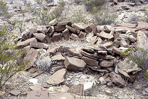
Cielo Complex structure in Chihuahua. Photo by R. Mallouf.
Source: Texas Beyond History
David Phillips
In Oasis America, the Archaic period (used here to mean the period between Paleoindian hunters and the adoption of pottery making) began after 11,000 BP and ended in most places in the early centuries A.D. We now know that after about 2100 B.C., the Archaic period included the growing of maize, a practice that spread to the culture area fropm Mesoamerica. In order to distinguish preceramic but agricultural peoples from earlier, non-agricultural ones, many archaeologists have adopted Bruce Huckell's [1990] "Early Agricultural period." The transition to agriculture was never complete, however. Portions of Sonora and Chihuahua, and all of Coahuila, maintained a foraging lifestyle until after the arrival of the Spanish.
Archaic Lifeways: Chihuahua and Adjacent Regions
For many years, Archaic period remains in northwest Mexico were simply attributed or compared to those of the Cochise Culture, an Archaic sequence defined in in southern Arizona. In northern Chihuahua, the first serious alternative sequence was proposed by MacNeish and Beckett (1987), who defined an "Archaic Chihuahua Tradition" based on excavations in southern New Mexico. Their basis for extending the tradition into Chihuahua may be extensive but mostly unreported activities in northeast Chihuahua by avocational archaeologists, many of them from El Paso.
In Southeast Chihuahua, our understanding of the Archaic period depends heavily of research in trans-Pecos Texas. The first substantial occupation of that part of Texas, and of adjacent Chihuahua, seems to have been in the Late Archaic period (1000 B.C.–A.D. 700). The variety of dart points suggests that people moved into the area from the southern Great Plains, possibly (as Mallouf has suggested) in response to shifts in herds of bison. Later, during the Late Prehistoric period, the Livermore phase (A.D. 800–1200) represents a continued reliance on wild foods, but with a switch from atlatls and darts to bows and arrows (the latter tipped with the distinctive, almost cross-shaped Livermore points). Even though the La Junta area saw the establishment of a semisedentary community after 1200 (see "Southeast Chihuahua"), the region continued to be home to full-time foragers (of the Cielo Complex, A.D. 1300–1680; characterized by Perdiz points and stone-circle dwelllings). As a parenthetical note, Archaic point typologies based on work in Texas seem to apply as far south and west as central, west-central, and southern Chihuahua. This typological continuity suggests that there were behavioral continuities as well.
Cielo Complex structure in Chihuahua. Photo by R. Mallouf.
Source:
Texas Beyond History
Other work in Chihuahua has documented Archaic period occupations, but not as part of a complete sequence like the ones just mentioned. In the Sierra Madre Occidental, in Swallow Cave (Cueva de las Golondrinas), Cave Valley (Valle de las Cuevas), Robert Lister (1958) found probable late Archaic remains, albeit based on limited evidence (some flaked stone and three maize cobs, found well below the Ceramic period deposits). Far to the south in the same range, Zingg (1940) located probable preceramic deposits, but again based on limited evidence, in 1931. MacWilliams et al. comment on Zingg's work as follows:
At Zingg's "Cave A," located 2 km northeast of Norogachi, the lowest excavation levels contained lithics without ceramics. He did not report maize from these lower levels. This did not deter Zingg (1939:212) from concluding that a local sequence began with "Rio Fuerte Basketmaker" cave inhabitants who farmed maize but lacked beans and pottery (MacWilliams et al. 2008:40).
Survey and testing data (the latter from caves) in the same general area documenting the presence of people in southwestern Chihuahua "no later than late Middle Archaic period" (MacWilliams et al. 2008:46; see also Hard et al. 2010). Thus far, the data are limited and do not include evidence for farming before about A.D. 1.
Arturo Guevara (1982) documented looted burial bundles from Cueva de los Gentiles in Municipio Bocoyna, which straddles the continental divide. The burial bundles are similar to those from Cueva de la Candelaria in Coahuila [Aveleyra et al. 1956] and thus likely to be Archaic. The Chihuhua examples included at least 12 adults and four children who had been wrapped in cloth and mats and tied into bundles.
In the Laguna Bustillos basin of central Chihuahua, numerous Archaic period sites have been found (MacWilliams 2001). Most of those sites are clustered on the downwind (northeast) side of the lake, in a dune field built of sand from the lake. The dune field has been deforested and is eroding rapidly, exposing artifacts and fire-cracked rock. Local inhabitants have collected jars of projectile points from the eroded areas. Art MacWilliams comments,
In 20 dunefield sites pre-Ceramic period projectile points are more abundant than sherds. Scattered hearths and round shaped one-hand manos also occur in most dunefield sites. The largest of these exceed 50,000 m2 and are accumulations from recurrent use over thousands of years. Site boundaries are largely a consequence of where sand is shifted—all deflated parts of the dunefield have at least dispersed lithics (MacWilliams 2001:137).
Archaic period sites of the Bustillos Basin are generally higher above the current lake than Ceramic period sites (MacWilliams 2001:139), so the lake may have been larger during the Archaic period.
Jerimy Cunningham (2009) reports lithic artifact scatters along the Rio Santa Maria indicating that the valley was occupied in the middle Archaic period and more intensivly during the late Archaic period. Also, one fortified hilltop may have been established during the Archaic period and reused during the Ceramic period. Diagnostic materials include a Pandale point and Shumla points.
J. Charles Kelley (1956, 1989) mentioned deeply buried preceramic deposits along the lower Rio Conchos. Working in Durango, Spence (1971) identified the Los Caracoles complex (3000 BP–A.D. 1), an Archaic culture usually thought to be directly ancestral to Loma San Gabriel.
Archaic Lifeways: Sonora and Northern Sinaloa
On the west side of the Sierra Madre Occidental, the Cochise Culture sequence continues to be the standard interpretive framework for Archaic period remains. In the Concepción drainage of Sonora, Bowen (1976) defined a "Phase 1" or Archaic occupation (3500 BP?–A.D. 200?) ancestral to the Trincheras culture. McGuire and Villapando also identified preceramic sites in that drainage, specifically in the Altar Valley, noting that the remains "easily fit in the Cochise culture of southern Arizona" (McGuire and Villalpando 1993:71). More recent information from the site of La Playa indicates a local occupation beginning about 2500 B.C. (including Chiricahua, Cortaro, and Gypsum points) and continuing into the Early Agricultural period (see below)(Carpenter 2009).
Near Hermosillo, George Fay (1967) documented Archaic period sites of what he called the "Peralta complex," which he suggested was possibly related to the Cochise Culture. Outside Guaymas, he documented aceramic and presumably preceramic sites (1956, 1968) but did not assign them to a specific culture.
John Carpenter and Guadalupe Sánchez (2008:23, tr.) report Archaic remains, including Cortaro points, from northern Sinaloa but add, "Unfortunately, we know nothing about [Sinaloa's] human populations during the Archaic period, or about their cultural adaptations."
Julian Hayden (1967, 1976) classified the Archaic period remains of the Pinacate country (northwest Sonora) as belonging to the Amargosa complex (7000 BP–A.D. 300). The complex may have included "geoglyphs" (Hayden 1982, Montané 1985), albeit the dating of such figures is tricky at best.
Rock Art
Polly Schaafsma's (1980) studies of rock art indicate that several Archaic rock art styles occur in, or extend into, northern Mexico. Arturo Mendiola G. (2007) illustrates rock art along the lower Rio Conchos that includes Shumla points and atlals.
The Emergence of Farming Communities
For many years, archaeologists assumed that farming spread north from Mesoamerica by a process of "diffusion" (that is, by being passed from one group to the next). Today, the reigning model states that farmers who spoke proto-Uto-Aztecan spread northward [Hill 2001–2003; Valiñas C. 2000]. For archaeologists' discussions of the issue, see Carpenter et al. (2002, 2003) and LeBlanc (2008), who concur. See also Mabry et al. (2008), who conclude that the process was much complex than the model proposes.
In parts of Northwest Mexico,the final part of the Archaic period involved not just domesticated foods but a degree of occupational intensity once assumed to have been absent until the Ceramic period. In northwest Chihuahua, study of Cerro Juanaqueña radically changed our understanding of the Chihuahua Archaic (Hard and Roney 1998; Hard et al. 1999, 2006; Roney and Hard 2002, 2003, 2004). The site is a cerro de trincheras (terraced hill) overlooking the floodplain of the Rio Casas Grandes and was occupied from 1350–1300 until 1100 B.C. (with minor occupation of the lower terraces between 400 B.C. and A.D. 1). The inhabitants subsisted on maize, possibly on domesticated amaranth, and a variety of wild forbs and grasses, jackrabbits, cottontails, fish, and occasional deer and pronghorn. Abundant, heavily worn ground stone indicated a heavy reliance on ground seeds.
Building Cerro Juanaqueña required an estimated 30 person-years of labor, and the resulting terraces (more than 500) were used for living surfaces. The latter supported rock rings roughly 2.5 m in diameter; based on excavation, at least some rock rings were house bases. The project also tested three other, smaller cerros de trincheras along the Rio Casas Grandes and concluded that the sites were, at least in part, defensive in nature. All told, about a dozen of the early cerros de trincheras have been documented in the general vicinity of Janos. If Cerro Juanaqueña and its sister sites represent the spread of farmers at the expense of foragers, the immigrant population might well need to be prepared for attacks.
Working in the southern Chihuahua, in the higher basins of the Rio Conchos (Atlantic) watershed, archaeologists have tested what they term "D-shaped terrace sites" (Hard et al. 2006, 2010; MacWilliams et al. 2008) and what Richard Brooks (1971:169) mentioned as "platform shelter sites."
The constructed terraces follow cliff bases for 20 to 25 meters, defining the straight side of an uppercase D, and arc out about 10 to 15 meters from cliffs, suggesting a notable labor investment. We tested three of these rockshelters during 2003 ... Work on the first was quickly abandoned due to pervasive rodent disturbance, but the other two proved more informative.
At Cueva de los Indios (C75-01), located 40 kilometers west of Ciudad Chihuahua, terrace deposits extended to 2.3 meters below surface ... The chipped stone assemblage includes at least 25 Middle Archaic and Late Archaic period projectile points and abundant bifacial reduction flakes. The faunal assemblage is remarkable for both its quantity ... and its compositions: 80% of the identified elements are tortoise and turtle ... Ceramic and Recent period components primarily rest above the Archaic materials, and a Plainview point base reveals that some Paleoindian materials are deep in the terrace fill.
Sitio Pienso (A47-05) is another D-shaped terrace rock-shelter site located northwest of Parral ... More than one dozen projectile points from this site derife from the late Middle Archaic to the Late Archaic periods. A 1 by 2 meter excavation produced more than 4,000 pieces of flaked stone, 25% of it from biface reduction, and not a single ceramic sherd. A diverse faunal assemblage includes turtle, tortoise, jackrabbit, cottontail, and mule deer ... Cobble manos, a small grinding slab, charcoal, and fire-cracked rock were also present. ... [A] date of 2770 ± 40 BP (Beta 182382) on a charred walnut shell is in line with the cultural assemblage. Maize was not recovered in our limited excavations or flotation samples [Hard et al. 2010:77].
As the final comment indicates, thus far there is no direct evidence for farming at the D-shaped terrace sites—but keeping the Cerro Juanaqueña complex in mind, these fairly labor-intensive and apparently preceramic sites seem like good candidates for Early Agricultural use of southern Chihuahua. There are, by the way, cerros de trincheras in northern Durango and southern Chihuahua (Raymond 2001; Raymond et al. 2003). Thus far, they have proven to date primarily to the Ceramic period (MacWilliams et al. 2008:44–45), but Hard et al. (2010:78) nonetheless argue for initial, Early Agricultural period occupation of a series of cerros de trincheras extending from that area to the Rio Casas Grandes valley and to Tumamoc Hill in Tucson, Arizona.
In Sonora, the La Playa site in the Concepción basin is a sprawling (12 square km) open-air site where erosion has exposed an intensive Archaic period occupation.
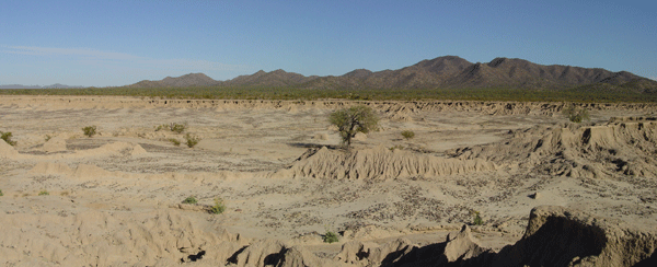
La Playa, Sonora. Erosion has removed much of the site, but has
also exposed remains for study. The incipient desert pavement in
the eroded area consists mostly of fire-cracked rock. Photo by the
Proyecto La Playa; used by permission.
Remains at the site resemble those of the San Pedro and Cienega phases of southern Arizona, and thus probably date between 1200 B.C. and A.D. 50. Erosion probably destroyed most of the houses. Surviving features include
human and animal cremations, dog burials, a variety of pits, flaked stone scatters, ground stone caches, two structures ... a probable pithouse, geoglyph figures, petroglyphs, about eighty-six acres [35 ha] of probable linear-bordered agricultural fields, irrigation canals, and a quarry for arkosic schist used mainly to make reamers and rasps used in manufacturing shell ornaments.
The most common feature at La Playa was the horno [pit oven]. More than 1,300 hornos, ranging from about two to sixty-six feet in diameter, have been documented. While the majority appear to have been used by households, the largest hornos may indicate communial feasting. One horno contained the remains of at least ten redtail hawks.
Although maize was important to the residents of La Playa, wild plants, such as amaranth, chenopodium, mesquite, and cactus, continued to be used. Evidence was also found for the hunting and consumption of deer, antelope, rabbit, hare, tortoise, and desert bighorn. Fish and crab were transported to the site from the Sea of Cortez, about sixty-two miles [100 km] away.
The most important craft undertaken at La Playa was the production of shell ornaments. Fifty-nine marine shell species have been identified, though Glycymeris is by far the most common shell recovered (Carpenter et al. 2009:14).
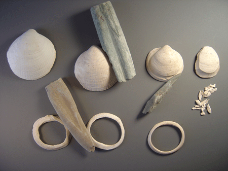
Shell ornaments in various stages of production, and stone tools
used for making ornaments, from La Playa, Sonora. Photo by Proyecto
La Playa; used by permission.
Similarly intensively used sites occur in the Tucson basin and archaeologists have found irrigation systems coeval with those sites. For a good recent summary and photographs of Early Agricultural period fields, see Archaeology Southwest 23(1). Even so, the regional adoption of farming was more of an evolution than a revolution. In discussing La Playa, John Carpenter (2009:53, tr.) describes a "Sonoran Agricultural Complex" that combined "the intensive cultivation of maize with the intensive exploitation of local plants and wild animals." He continues:
Without a doubt, maize constituted an important resource that was stored for use in the winter and spring. Nonetheless, and even though the settlement pattern was totallly sedentary and agricultural strategies were intensified, maize appears to have contributed a small percentage of the total calories being consumed (Carpenter 2009:53, tr.).
Meanwhile, in other parts of Oasis America, local peoples made little or no adjustment in their foraging lifeways, despite the newly arrived cultigens. As archaeologists work to explain the transition from foraging to farming, the unevenness of that transition must also be explained.
Link: Texas Beyond History (includes the nomadic cultures of the La Junta area).