David Phillips
The Casas Grandes (or Chihuahua) culture has always been the best known of the prehistoric cultures of northwest Mexico. International awareness of the culture first derived from its polychrome pottery (which was, and is, popular in the black market in antiquities) and from the massive ruins of the culture's principal center, Casas Grandes—now better known as Paquimé.
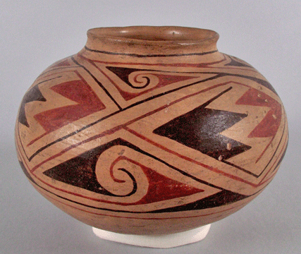
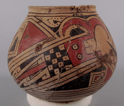
The florescence of the Casas Grandes culture is marked by the presence of distinctive polychromes (Sayles 1936; Di Peso et al. 1974). The various Medio polychrome types can be broken down into two basic painting styles, "Babicora" and "Ramos" (Phillips 2009). In "Babicora style" designs the red and black paint do not touch. This style occurs on Babicora Polychrome (smoothed but unslipped brown vessls) and most examples of Villa Ahumada Polychrome (off-white slip), Carretas Polychrome (orange-tinged clay), and Huerigos Polychrome (same clay as Carretas, but slipped). The "Babicora" tradition is an outgrowth of the late Viejo period painting styles. In contrast, the "Ramos" style—in which red paint is outlined in black—appears to be an intrusive style, possibly derived from Mimbres Polychrome. The "Ramos style" occurs on Ramos Polychrome vessels and on a few examples of Villa Ahumada, Carretas, and Huerigos Polychrome.
Left: Babicora Polychrome; Maxwell Museum Catalogue No. 65.24.35.
Right: Ramos Polychrome; Maxwell Museum Catalogue No. 68.13.33
(see the final note).
The Medio period polychrome types cluster in specific areas (see next figure). The types also show some temporal variation in frequency (Rakita and Raymond 2003; Whalen and Minnis 2009). Whalen and Minnis draw on stratigraphic and radiocarbon data to argue that Ramos Polychrome did not appear until A.D. 1300 or shortly before, and that the Medio period can be devided into early (pre-1300) and late (post-1300). This division correlates, at least roughly, with a division between the Buena Fe and combined Paquimé-Diablo phases defined by Di Peso. Still much remains to be done on Medio period ceramic chronology.
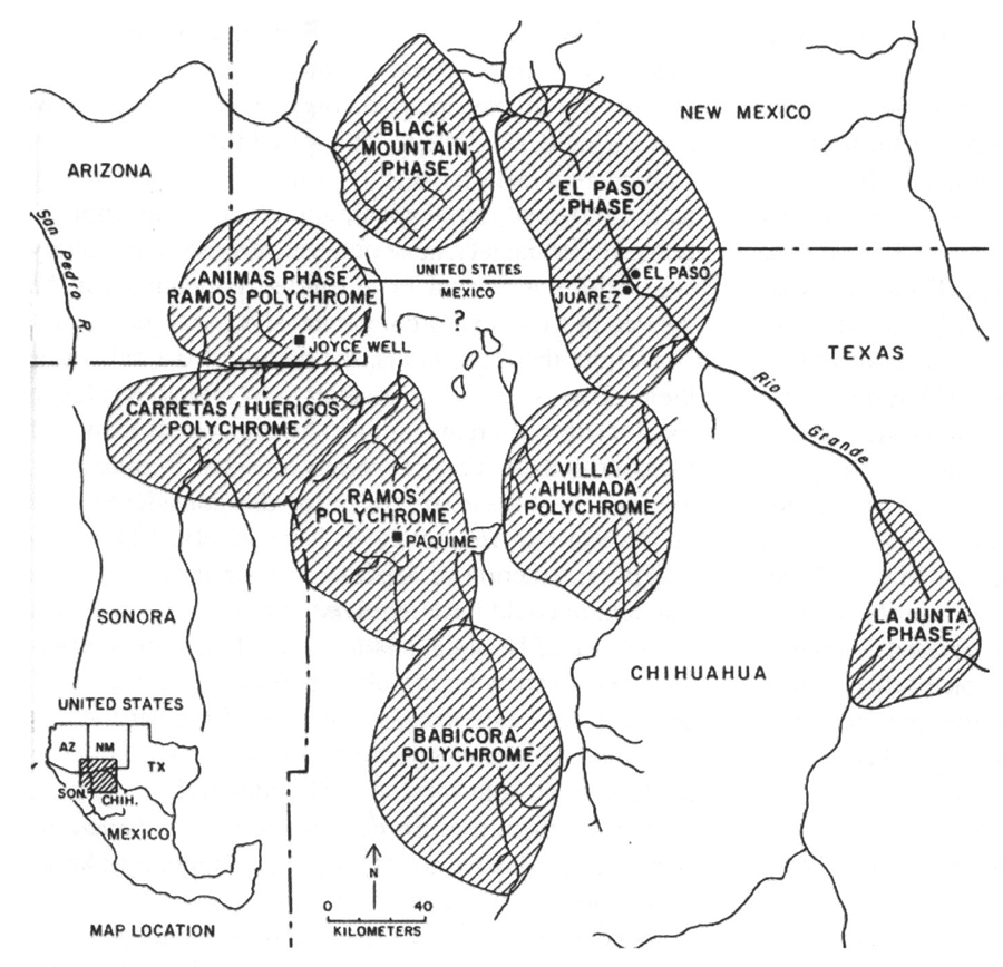
Distribution of Casas Grandes polychromes styles. Locations of
contemporary related phases are also shown. From Fish et al. (2006,
Figure 3.10), based in turn on Carpenter (1992).
The finest Casas Grandes polychromes are usually Ramos Polychrome, and the skill, standardization, and iconographic content show that some vessels were more than folk art. Sprehn (2003, 2006) concludes that some of the Casas potters were specialists and that "some vessels appear to have been solely produced for elite purposes" (Sprehn 2006:48). At Paquimé, especially large Ramos Polychrome vessels were used as funerary urns for high-ranking members of the community (Di Peso 1974).
Paquimé: The Cornerstone of Casas Grandes Archaeology
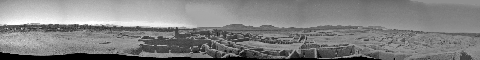
Paquimé in 1987 (panorama) Click on photo for larger version.
Professional awareness of the Casas Grandes culture was minimal until a project led by Charles Di Peso of the Amerind Foundation (Di Peso 1974; Di Peso et al. 1974) with the support of Eduardo Contrera of INAH (Contrera 1970, 1985). Ever since, all understanding of the Casas Grandes culture begins with with Di Peso's work at Paquimé. Di Peso did not limit himself to one site, however. Instead he set out to create as complete a cultural sequence for the Casas Grandes area as he could manage. The associated chronology has since been reworked but remains by far the best framework for regional chronology building.
Immediately after the collapse of the great Mimbres villages about 1150, there may have been as much as a half-century of disorganization in this part of Oasis America. If so, a new social order—the Medio period of the Casas Grandes culture—had crystallized by about 1200, and lasted until as late as 1450 (Phillips 2008). The culture's leading center, Paquimé, consisted of massive-walled, contiguous, multi-story adobe room blocks strung along the edge of a low terrace overlooking the Rio Casas Grandes. Surrounding this site "core" was a halo of lower (probably single story) room blocks, platform mounds, and ball courts (Phillips and Bagwell 2001).

Massive room walls at Paquimé. Photo by D. Phillips.
Composite of Maxwell Mus. Cat. Nos. 2007.80.390
and 2007.80.391 (see end note).
Contrera (1985) and Di Peso et al. (1974) describe construction methods used at the site. Noteworthy architectural elements included odd-shaped rooms, large rooms with massive post supports, T-shaped doorways, raised hearths, and alcove platforms suitable for living, sleeping, and storage. The site was served by a canal system for domestic water and by drains. Total site size was about 36 hectares (Whalen and Minnis 2009:199). Roads occur in the vicinity (noted by John Roney) and a floodplain feature described by Adolph Bandelier (in Lange and Riley 1970:296) at Paquimé is most likely also a road. The roads, the great I-shaped ball court that survives, the platform mounds, and colonnaded entry rooms all point to Mesoamerica as a source of inspiration (at the least) about how to do public architecture.
The preeminence of the site is indicated by the richness of its deposited treasures. One room contained millions of sea shells. The site included breeding areas for macaws and hundreds of macaw burials. Copper from Mesoamerica and turquoise from the U.S. Southwest were also present, but in relatively modest amounts; for those items, at least, Paquimé was not the main destination.
At the top of Cerro de Moctezuma, 5 km west of Paquimé, the Casas Grandes people built a circular structure or atalaya that may have served as a beacon. Lesser line-of-sight features elsewhere suggest that northwest Chihuahua shared a signal system (Swanson 1997, 2003). Other features at Cerro de Moctuzuma include a cave, a small village with adobe and rock walls (El Pueblito), a reservoir, a field system that incorporates an horno, and trails (Pietzel 2003, 2007). Given the mix of features, Pietzel concludes that the mountain served as an extension of Paquimé where "sacred rituals of a regional importance may have been performed and signaled across the vast landscape" (Pietzel 2007:366).

El Pueblito on Cerro de Moctezuma. Source:
G. Rakita.
Paquimé's riches and Mesoamerican flavor was the key to Di Peso's radical reintepretation of Greater Southwestern prehistory, the puchteca concept. According to Di Peso (1974), Mesoamerican merchant-warriors (which he modeled after the Aztec pochteca) first manipulated the historical trajectory of the culture area, then established Paquimé in order to control that area more directly. When the Toltec hegemony collapsed, Paquimé became vulnerable and was overrun. A remnant group of Casas Grandes people survived in the Sierra Madre Occidental, and engaged in a battle with Spanish explorers before disappearing.
Di Peso's reconstruction gained little acceptance, however, in part because of a reluctance to see that extensive an intervention by Mesoamericans, and in part because of problems with his dating of the Casas Grande culture sequence. Michael Whalen and Paul Minnis, who see developments as more locally driven, have summarized the alternative position as follows:
This argument sees Paquimé as occupying a favorable ecological position that allowed it to prosper and grow beyond its neigbors. Emerging elite people at Paquimé used their increasing wealth to import some elements of ritual and some prestige goods from ... northwestern Mesoamerica. Ethnographic and prehistoric contexts all over the world show that this is is a common strategy by which aspiring people or groups gain and enhance social power. In this view, Paquimé is one of prehistoric North America's few examples of indigenous complex society development (Whalen and Minnis 2009:201–202).
Stephen Lekson has argued, as did Di Peso, that the Medio period was sparked by outsiders—in this case, the Chaco Canyon elite (Lekson 1999). Lekson noticed that that the center of Chaco Canyon and the site of Paquimé share the same longitude, and proposes that when the Chaco elite abandoned Chaco, they marched in a ritually dictated, carefully measured line due south until establishing Paquimé. He adds the wrinkle that first they moved north, establishing the Aztec Ruin complex.
Elsewhere, I have criticized the hypothesis (Phillips 2002) in detail. Here my main complaint is Lekson's logical inconsistency. The most serious example is whether meridian-chasing could be honored in the breach (i.e., was a concept only) or had to be done with rigid accuracy. The Aztec Ruin complex is not due north of "downtown" Chaco, so Lekson states that it was possible, in practice, to wander off a true north-south line. If this is true, however, when the same elite wandered from Aztec to Paquimé over a much more challenging piece of the earth's surface, they should have altered course from time to time and Paquimé should not have ended up on the exact longitude meridian of "downtown" Chaco. By Lekson's own logic, the sharing of the meridian must be a coincidence.
For those less concerned with issues of logic, suffice it to say that the available evidence is more consistent with Medio period Casas Grandes villages arising from the Viejo period villages than it is with the Medio period being instigated by itinterant Chacoans. Medio period pottery is clearly derived from Viejo period pottery, for example, not from Chaco pottery. Based on studies by John Ravesloot (1984, 1988), Gordon Rakita (2001), and Christine VanPool (2003), the indigenous leadership that emerged in the Medio period most likely consisted of hereditary priests who marked their leadership through ancestor worship and who engaged in shamanic rituals on behalf of the greater community.
The occupation of Paquimé seems to have changed radically through time. The excavated room blocks were built as series of large, carefully made rooms and involved a great deal of formal as opposed to strictly functional space—in other words, the architecture of power. Later, the spaces were subdivided, usually with more expedient walls, and occupied more in tenement fashion. Di Peso (1974; Di Peso et al. 1974) codified this shift as the shift from the Paquimé phase to the Diablo phase. It may be closer to the mark to state that the shift took place about A.D. 1300. Although the occupation shift suggests a breakdown in elite authority at Paquimé, craft production and macaw raising continued.
The changing nature of occupation at Paquimé bears on our interpretation of how "Mesoamerican" the site was. Di Peso estimated a peak population of 4,700 (Di Peso et al. 1974:198, 207 but if so, this peak came after the breakdown of Mesoamerican-like uses of architectural space; the population before A.D. 1300 would have been lower. In any case, Di Peso seems to have overestimated the extent of the prehistoric site and thus its population size (Phillips and Bagwell 2001). The peak population was more likely close to 3,000, more in line with that of the other largest villages of the Greater Southwest.
Di Peso argued that about 1340, Paquimé was sacked, with the dead to lie where they fell. From a taphonomic view if no other, this intepretation seems extreme. It appears instead that many of the burials within the site were expedient, an interesting fact in itself (see Ravesloot 1988). The inhabitants of the site probably left in the early 1400s, about the same time that the entire culture fell apart (Phillips 2008). Di Peso (1974) argued for a late survival of the Casas Grandes culture in the Sierra Madre Occidental, but the sites in question are more likely to date to the Medio period (Phillips 2008; Phillips and Carpenter 1999).
The Casas Grandes "Core Community"
Although Paquimé appears to have been the principal town of an ancient community, that community existed long before Paquimé was established. With his usual thoroughness, Di Peso excavated the Convento Site, just north of Viejo Casas Grandes, to document both the pre-Paquimé occupation and the contact period occupation of the Casas Grandes Valley.
The earliest Ceramic period inhabitants of northwest Chihuahua may have produced only plainware pottery. If so, the only evidence thus far for that occupation is the limited plainware deposits found in the Sierra Madre by Robert Lister (1958). The Di Peso sequence begins with the Convento and Pilón phases of the Viejo period (roughly A.D. 600 to 1100), which included red-on-brown pottery. The Convento site's inhabitants lived in small pit houses. One especially large pit structure indicates the presence of community level ritual.
More recently, Whalen and Minnis (2009) have documented two pit structures beneath the Medio period remains at the Tinaja Site (Site 204), in a side valley not far from Paquimé. The averaged two sigma date range for the pit houses is A.D. 1030–1160, which would place them in Di Peso's Pilón phase. Whalen and Minnis have documented a third Viejo period pit structure, albeit not as clearly dated, at their Site 317.
In the Perros Bravos phase (A.D. 1100 to 1200?), the site's occupants built clusters of two or three rectangular surface rooms, joined by wing walls to form small plaza-like areas. The large ceremonial round house continued in use. Some of the corrugated-neck vessels include were painted in black as well as red, creating the first Casas Grandes polychrome pottery. Imported goods included Mimbres black-on-white pottery (from the north) and occasional items of copper (from Mesoamerica). Mimbres black-on-white sherds are actually widespread in the Casas Grandes area, and inidicate that the late Viejo period villages were part of the sphere of people with a client relationship with the Mimbres culture. On the whole, the late Viejo remains at the Convento Site give no hint that the local valley was about to become one of the Oasis America's great centers.
The Viejo period remains exposed at the Convento by Di Peso, and those more recently identified by Whalen and Minnis, site are similar to those found by Jane Kelley and her colleagues well to the south. The combined data indicate a pattern of small agricultural villages, probably hundreds of them, scattered over multiple valleys on the eastern flank of the Sierra Madre Occidental. In other words, the community whence Paquimé sprang was one of many Casas Grandes communities.
In the Medio perod, as well, the local community included numerous villages besides Paquimé. Most of our understanding of the community comes from a multi-year survey and excavation project led by Michael Whalen and Paul Minnis. Based on that work, the two authors argue that Paquimé directly controlled the area within 30 km of itself. For people within 15 km of the site, rituals requiring public architecture seem to have taken place at Paquimé itself, and the local villages lack such architecture. At a distance of 15 to 30 km from Paquimé, some villages had public architecture, and thus appear to have been subsidiary centers. The modest size of the Paquimé polity–only 60 km across–contrasts sharply with Di Peso's claim that Paquimé exercised "command and control" over Oasis America.
Whalen and Minnis' project included extensive excavations at the Tinaja Site, in a small valley 17 km west of Paquimé. The site includes multiple residential mounds as well as hornos and a prominent I-shaped ball court. Living rooms were large and had hearths; entry was by T-shaped and rectangular doors. Storage rooms were smaller. An atalaya overlooking the site provides a visual link with Cerro de Moctezuma (Whalen and Minnis 2009, Figure 1.3). Based on a large sample of radiocarbon dates, the peak occupation of the Tinaja Site fell between A.D. 1350 and 1400 (Whalen and Minnis 2006; 2009). Nonetheless, Whalen and Minnis (2009:17) argue that the Medio period occupation of the site began "in the mid- to late 1100s rather than at the commonly accepted date [for the Medio period] of 1200." If this dating holds, it effectively closes the gap between the end of the Mimbres Classic florescence (ca. 1150) and the start of the Medio period.
Like the Tinaja Site, Site 242 appears to have been a subsidiary center of Whalen and Minnis' outer zone. The site is 27 km from Paquimé and includes a residential mound of unusual height, a ball court, and a platform mound. The site also includes arc-shaped stone features that may mark additional residences. In contrast, their Site 317 (19 km from Paquimé) does not appear to have been a subsidiary center. Instead it is a typical small village, including three small residential mounds and hornos. Another example of this type, Site 231 (20 km from Paquimé), includes a single residential mound (Whalen and Minnis 2009).
At one of the local Medio period settlements, Site 315, a single seed provides the only evidence of precolumbian domesticated chile in Oasis America (Minnis and Whalen 2010). The same deposit yielded evidence of maize, beans, cotton, prickly pear, goosefoot, amanranth, and possibly squash (Minnis and Whalen 2010:247), indicating the range of foods obtained from the irrigated floodplain of the Rio Casas Grandes and from the adjacent uplands.
Arturo Guevara S. (2006) has documented the village of Buena Fé across the Rio Casas Grandes from Paquimé, and the Ojo del Vareleño site at the spring that fed the Paquimé water system.
As soon as we move beyond the notion that Paquimé was the center of a vast sociopolitical web, ordinary research questions assert themselves. How, for example, did the local people obtain their food? The assumption is that Paquimé and its neighbors took advantage of the rich, easily irrigated bottomlands of the Rio Casas Grandes and its tributary streams, albeit modern use of the same valley bottom has masked the prehistoric evidence. Whalen and Minnis (2007, 2009) have documented the presence of check dams and similar agricultural features outside the local bottomland, and at least some of these features appear to have been used to grow agave. Whalen and Minnis suggest that some locations may have been "chief's fields." At present, however, we know surprisingly little about Medio period subsistence (and many other things). As current research continues to move away from the puchteca hypothesis, we should learn a great deal about ordinary life in prehistoric northwest Chihuahua.
Photos with catalogue numbers copyright © Maxwell Museum of Anthropology, University of New Mexico. High-resolution versons of the photographs may be ordered from the Maxwell Museum's photo archives. Please make note of the catalogue numbers. For more information please visit the photo archives web page